You are here: Home > Network List > TA - USArray Transportable Network (new EarthScope stations) Stations List
> Station G32A Webster, SD, USA > Earthquake Result Viewer
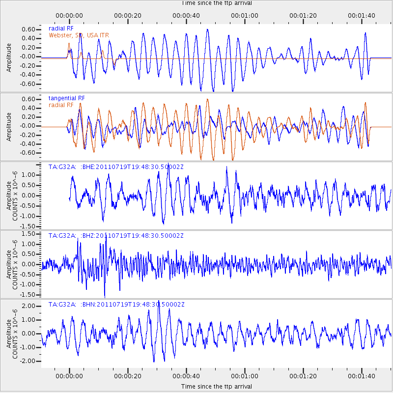
G32A Webster, SD, USA - Earthquake Result Viewer
*The percent match for this event was below the threshold and hence no stack was calculated.
| Earthquake location: |
Tajikistan |
| Earthquake latitude/longitude: |
40.1/71.4 |
| Earthquake time(UTC): |
2011/07/19 (200) 19:35:43 GMT |
| Earthquake Depth: |
20 km |
| Earthquake Magnitude: |
6.1 MB, 6.2 MS, 6.1 MW, 6.0 MW |
| Earthquake Catalog/Contributor: |
WHDF/NEIC |
|
| Network: |
TA USArray Transportable Network (new EarthScope stations) |
| Station: |
G32A Webster, SD, USA |
| Lat/Lon: |
45.26 N/97.50 W |
| Elevation: |
566 m |
|
| Distance: |
94.5 deg |
| Az: |
352.167 deg |
| Baz: |
8.513 deg |
| Ray Param: |
$rayparam |
*The percent match for this event was below the threshold and hence was not used in the summary stack. |
|
| Radial Match: |
36.774853 % |
| Radial Bump: |
400 |
| Transverse Match: |
35.356934 % |
| Transverse Bump: |
400 |
| SOD ConfigId: |
401841 |
| Insert Time: |
2011-12-21 05:59:50.969 +0000 |
| GWidth: |
2.5 |
| Max Bumps: |
400 |
| Tol: |
0.001 |
|
Signal To Noise
| Channel | StoN | STA | LTA |
| TA:G32A: :BHZ:20110719T19:48:30.50002Z | 2.7651865 | 4.6562644E-7 | 1.6838881E-7 |
| TA:G32A: :BHN:20110719T19:48:30.50002Z | 1.9702624 | 8.9214666E-7 | 4.5280603E-7 |
| TA:G32A: :BHE:20110719T19:48:30.50002Z | 1.9964832 | 8.612306E-7 | 4.3137385E-7 |
| Arrivals |
| Ps | |
| PpPs | |
| PsPs/PpSs | |


