You are here: Home > Network List > TA - USArray Transportable Network (new EarthScope stations) Stations List
> Station K37A Belmond, IA, USA > Earthquake Result Viewer
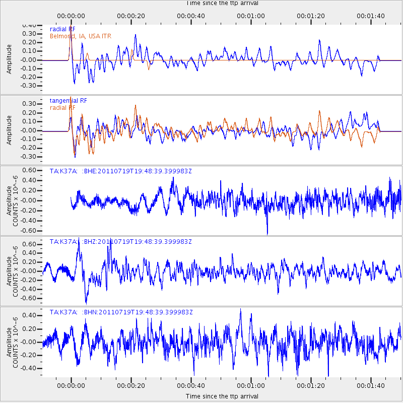
K37A Belmond, IA, USA - Earthquake Result Viewer
*The percent match for this event was below the threshold and hence no stack was calculated.
| Earthquake location: |
Tajikistan |
| Earthquake latitude/longitude: |
40.1/71.4 |
| Earthquake time(UTC): |
2011/07/19 (200) 19:35:43 GMT |
| Earthquake Depth: |
20 km |
| Earthquake Magnitude: |
6.1 MB, 6.2 MS, 6.1 MW, 6.0 MW |
| Earthquake Catalog/Contributor: |
WHDF/NEIC |
|
| Network: |
TA USArray Transportable Network (new EarthScope stations) |
| Station: |
K37A Belmond, IA, USA |
| Lat/Lon: |
42.77 N/93.64 W |
| Elevation: |
365 m |
|
| Distance: |
96.4 deg |
| Az: |
348.978 deg |
| Baz: |
11.49 deg |
| Ray Param: |
$rayparam |
*The percent match for this event was below the threshold and hence was not used in the summary stack. |
|
| Radial Match: |
65.10127 % |
| Radial Bump: |
400 |
| Transverse Match: |
50.22459 % |
| Transverse Bump: |
400 |
| SOD ConfigId: |
401841 |
| Insert Time: |
2011-12-21 06:15:49.495 +0000 |
| GWidth: |
2.5 |
| Max Bumps: |
400 |
| Tol: |
0.001 |
|
Signal To Noise
| Channel | StoN | STA | LTA |
| TA:K37A: :BHZ:20110719T19:48:39.399983Z | 2.782359 | 3.0076976E-7 | 1.0809884E-7 |
| TA:K37A: :BHN:20110719T19:48:39.399983Z | 2.0875773 | 1.8596143E-7 | 8.908002E-8 |
| TA:K37A: :BHE:20110719T19:48:39.399983Z | 2.445709 | 2.206738E-7 | 9.022897E-8 |
| Arrivals |
| Ps | |
| PpPs | |
| PsPs/PpSs | |


