You are here: Home > Network List > TA - USArray Transportable Network (new EarthScope stations) Stations List
> Station L39A Vinton, IA, USA > Earthquake Result Viewer
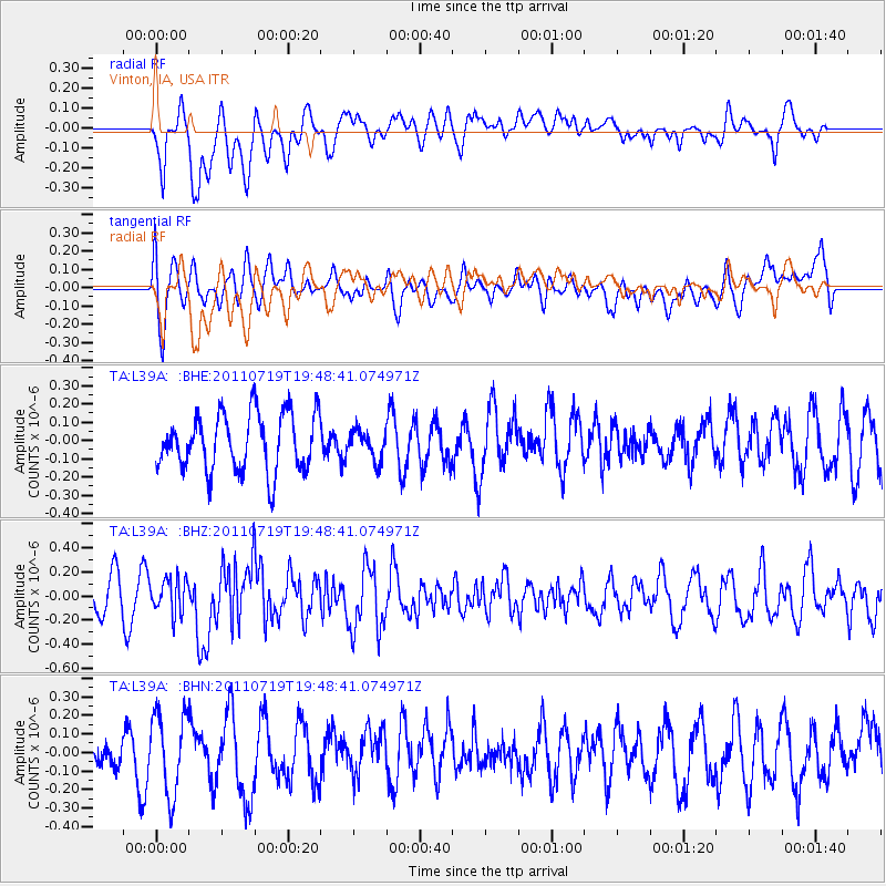
L39A Vinton, IA, USA - Earthquake Result Viewer
*The percent match for this event was below the threshold and hence no stack was calculated.
| Earthquake location: |
Tajikistan |
| Earthquake latitude/longitude: |
40.1/71.4 |
| Earthquake time(UTC): |
2011/07/19 (200) 19:35:43 GMT |
| Earthquake Depth: |
20 km |
| Earthquake Magnitude: |
6.1 MB, 6.2 MS, 6.1 MW, 6.0 MW |
| Earthquake Catalog/Contributor: |
WHDF/NEIC |
|
| Network: |
TA USArray Transportable Network (new EarthScope stations) |
| Station: |
L39A Vinton, IA, USA |
| Lat/Lon: |
42.12 N/92.00 W |
| Elevation: |
261 m |
|
| Distance: |
96.8 deg |
| Az: |
347.649 deg |
| Baz: |
12.745 deg |
| Ray Param: |
$rayparam |
*The percent match for this event was below the threshold and hence was not used in the summary stack. |
|
| Radial Match: |
58.896137 % |
| Radial Bump: |
400 |
| Transverse Match: |
44.686314 % |
| Transverse Bump: |
400 |
| SOD ConfigId: |
401841 |
| Insert Time: |
2011-12-21 06:17:14.583 +0000 |
| GWidth: |
2.5 |
| Max Bumps: |
400 |
| Tol: |
0.001 |
|
Signal To Noise
| Channel | StoN | STA | LTA |
| TA:L39A: :BHZ:20110719T19:48:41.074971Z | 1.2302136 | 1.4228267E-7 | 1.1565689E-7 |
| TA:L39A: :BHN:20110719T19:48:41.074971Z | 1.6901045 | 2.1813312E-7 | 1.2906489E-7 |
| TA:L39A: :BHE:20110719T19:48:41.074971Z | 0.49711236 | 7.7825916E-8 | 1.5655598E-7 |
| Arrivals |
| Ps | |
| PpPs | |
| PsPs/PpSs | |


