You are here: Home > Network List > IW - Intermountain West Stations List
> Station MOOW Moose Ponds, Wyoming, USA > Earthquake Result Viewer
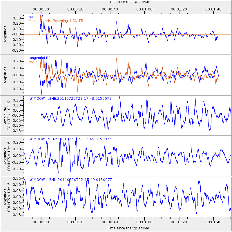
MOOW Moose Ponds, Wyoming, USA - Earthquake Result Viewer
*The percent match for this event was below the threshold and hence no stack was calculated.
| Earthquake location: |
Solomon Islands |
| Earthquake latitude/longitude: |
-10.3/162.0 |
| Earthquake time(UTC): |
2011/07/20 (201) 22:04:59 GMT |
| Earthquake Depth: |
21 km |
| Earthquake Magnitude: |
5.9 MB, 5.6 MS, 6.0 MW, 6.0 MW |
| Earthquake Catalog/Contributor: |
WHDF/NEIC |
|
| Network: |
IW Intermountain West |
| Station: |
MOOW Moose Ponds, Wyoming, USA |
| Lat/Lon: |
43.75 N/110.74 W |
| Elevation: |
2128 m |
|
| Distance: |
95.1 deg |
| Az: |
46.612 deg |
| Baz: |
260.65 deg |
| Ray Param: |
$rayparam |
*The percent match for this event was below the threshold and hence was not used in the summary stack. |
|
| Radial Match: |
69.31355 % |
| Radial Bump: |
396 |
| Transverse Match: |
58.552315 % |
| Transverse Bump: |
399 |
| SOD ConfigId: |
401841 |
| Insert Time: |
2011-12-21 06:40:34.982 +0000 |
| GWidth: |
2.5 |
| Max Bumps: |
400 |
| Tol: |
0.001 |
|
Signal To Noise
| Channel | StoN | STA | LTA |
| IW:MOOW: :BHZ:20110720T22:17:49.015007Z | 2.7189362 | 1.208725E-7 | 4.4455806E-8 |
| IW:MOOW: :BHN:20110720T22:17:49.015007Z | 0.749466 | 4.677214E-8 | 6.240729E-8 |
| IW:MOOW: :BHE:20110720T22:17:49.015007Z | 0.68916583 | 3.414209E-8 | 4.9541182E-8 |
| Arrivals |
| Ps | |
| PpPs | |
| PsPs/PpSs | |


