You are here: Home > Network List > TA - USArray Transportable Network (new EarthScope stations) Stations List
> Station N02D Trinity Center, CA, USA > Earthquake Result Viewer
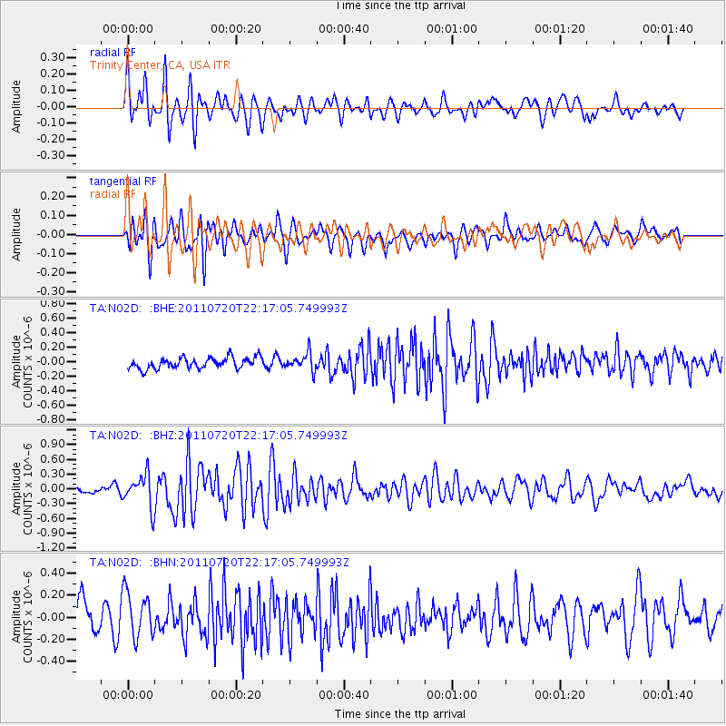
N02D Trinity Center, CA, USA - Earthquake Result Viewer
*The percent match for this event was below the threshold and hence no stack was calculated.
| Earthquake location: |
Solomon Islands |
| Earthquake latitude/longitude: |
-10.3/162.0 |
| Earthquake time(UTC): |
2011/07/20 (201) 22:04:59 GMT |
| Earthquake Depth: |
21 km |
| Earthquake Magnitude: |
5.9 MB, 5.6 MS, 6.0 MW, 6.0 MW |
| Earthquake Catalog/Contributor: |
WHDF/NEIC |
|
| Network: |
TA USArray Transportable Network (new EarthScope stations) |
| Station: |
N02D Trinity Center, CA, USA |
| Lat/Lon: |
40.97 N/122.71 W |
| Elevation: |
937 m |
|
| Distance: |
85.8 deg |
| Az: |
47.248 deg |
| Baz: |
252.598 deg |
| Ray Param: |
$rayparam |
*The percent match for this event was below the threshold and hence was not used in the summary stack. |
|
| Radial Match: |
74.780464 % |
| Radial Bump: |
400 |
| Transverse Match: |
54.245617 % |
| Transverse Bump: |
400 |
| SOD ConfigId: |
401841 |
| Insert Time: |
2011-12-21 06:45:09.793 +0000 |
| GWidth: |
2.5 |
| Max Bumps: |
400 |
| Tol: |
0.001 |
|
Signal To Noise
| Channel | StoN | STA | LTA |
| TA:N02D: :BHZ:20110720T22:17:05.749993Z | 5.533694 | 3.3402628E-7 | 6.036227E-8 |
| TA:N02D: :BHN:20110720T22:17:05.749993Z | 1.6881126 | 2.0311543E-7 | 1.2032102E-7 |
| TA:N02D: :BHE:20110720T22:17:05.749993Z | 1.5865825 | 1.212565E-7 | 7.642622E-8 |
| Arrivals |
| Ps | |
| PpPs | |
| PsPs/PpSs | |


