You are here: Home > Network List > UW - Pacific Northwest Regional Seismic Network Stations List
> Station LEBA Lebam, WA, USA > Earthquake Result Viewer
LEBA Lebam, WA, USA - Earthquake Result Viewer
*The percent match for this event was below the threshold and hence no stack was calculated.
| Earthquake location: |
Solomon Islands |
| Earthquake latitude/longitude: |
-10.3/162.0 |
| Earthquake time(UTC): |
2011/07/20 (201) 22:04:59 GMT |
| Earthquake Depth: |
21 km |
| Earthquake Magnitude: |
5.9 MB, 5.6 MS, 6.0 MW, 6.0 MW |
| Earthquake Catalog/Contributor: |
WHDF/NEIC |
|
| Network: |
UW Pacific Northwest Regional Seismic Network |
| Station: |
LEBA Lebam, WA, USA |
| Lat/Lon: |
46.55 N/123.56 W |
| Elevation: |
73 m |
|
| Distance: |
86.9 deg |
| Az: |
41.745 deg |
| Baz: |
251.658 deg |
| Ray Param: |
$rayparam |
*The percent match for this event was below the threshold and hence was not used in the summary stack. |
|
| Radial Match: |
69.04213 % |
| Radial Bump: |
400 |
| Transverse Match: |
66.71961 % |
| Transverse Bump: |
400 |
| SOD ConfigId: |
401841 |
| Insert Time: |
2011-12-21 06:49:13.164 +0000 |
| GWidth: |
2.5 |
| Max Bumps: |
400 |
| Tol: |
0.001 |
|
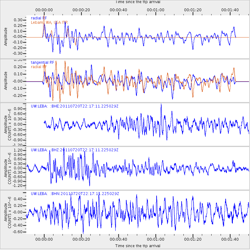
Signal To Noise
| Channel | StoN | STA | LTA |
| UW:LEBA: :BHZ:20110720T22:17:11.225029Z | 4.944755 | 4.663085E-7 | 9.430366E-8 |
| UW:LEBA: :BHN:20110720T22:17:11.225029Z | 1.2678272 | 1.4515939E-7 | 1.1449462E-7 |
| UW:LEBA: :BHE:20110720T22:17:11.225029Z | 1.0537797 | 1.7453964E-7 | 1.6563199E-7 |
| Arrivals |
| Ps | |
| PpPs | |
| PsPs/PpSs | |


