You are here: Home > Network List > UW - Pacific Northwest Regional Seismic Network Stations List
> Station PASS Maple Falls, WA, USA > Earthquake Result Viewer
PASS Maple Falls, WA, USA - Earthquake Result Viewer

| Earthquake location: |
Xizang |
| Earthquake latitude/longitude: |
31.3/86.5 |
| Earthquake time(UTC): |
2014/03/30 (089) 17:10:14 GMT |
| Earthquake Depth: |
13 km |
| Earthquake Magnitude: |
5.3 MW |
| Earthquake Catalog/Contributor: |
ISC/ISC |
|
| Network: |
UW Pacific Northwest Regional Seismic Network |
| Station: |
PASS Maple Falls, WA, USA |
| Lat/Lon: |
49.00 N/122.09 W |
| Elevation: |
174 m |
|
| Distance: |
96.1 deg |
| Az: |
18.457 deg |
| Baz: |
335.713 deg |
| Ray Param: |
0.040618096 |
| Estimated Moho Depth: |
60.5 km |
| Estimated Crust Vp/Vs: |
1.93 |
| Assumed Crust Vp: |
6.566 km/s |
| Estimated Crust Vs: |
3.398 km/s |
| Estimated Crust Poisson's Ratio: |
0.32 |
|
| Radial Match: |
97.09731 % |
| Radial Bump: |
77 |
| Transverse Match: |
49.067318 % |
| Transverse Bump: |
384 |
| SOD ConfigId: |
3390531 |
| Insert Time: |
2019-04-10 23:07:44.294 +0000 |
| GWidth: |
2.5 |
| Max Bumps: |
400 |
| Tol: |
0.001 |
|
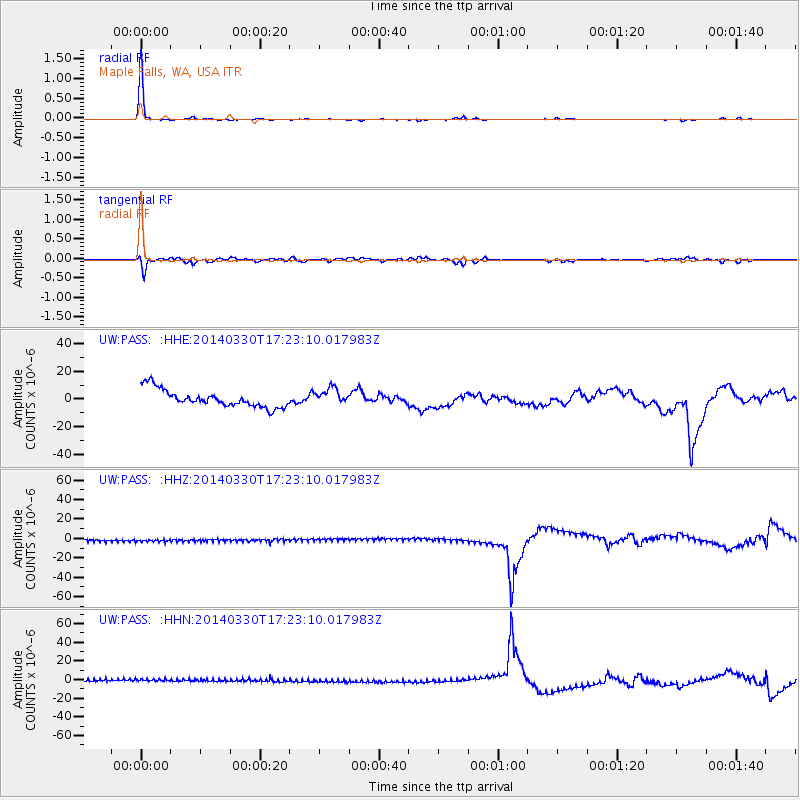
Signal To Noise
| Channel | StoN | STA | LTA |
| UW:PASS: :HHZ:20140330T17:23:10.017983Z | 1.0424373 | 2.8652578E-6 | 2.748614E-6 |
| UW:PASS: :HHN:20140330T17:23:10.017983Z | 1.0435942 | 2.9962741E-6 | 2.8711104E-6 |
| UW:PASS: :HHE:20140330T17:23:10.017983Z | 0.9573907 | 5.983014E-6 | 6.2492913E-6 |
| Arrivals |
| Ps | 8.8 SECOND |
| PpPs | 27 SECOND |
| PsPs/PpSs | 35 SECOND |


