You are here: Home > Network List > G - GEOSCOPE Stations List
> Station CAN Canberra, Australia > Earthquake Result Viewer
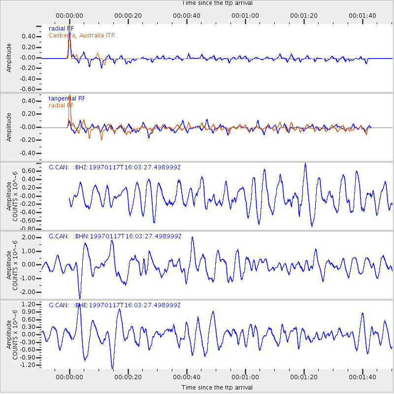
CAN Canberra, Australia - Earthquake Result Viewer
*The percent match for this event was below the threshold and hence no stack was calculated.
| Earthquake location: |
Ryukyu Islands, Japan |
| Earthquake latitude/longitude: |
28.8/130.0 |
| Earthquake time(UTC): |
1997/01/17 (017) 15:53:13 GMT |
| Earthquake Depth: |
33 km |
| Earthquake Magnitude: |
5.9 MB, 6.3 MS, 6.3 UNKNOWN, 6.2 MW |
| Earthquake Catalog/Contributor: |
WHDF/NEIC |
|
| Network: |
G GEOSCOPE |
| Station: |
CAN Canberra, Australia |
| Lat/Lon: |
35.32 S/149.00 E |
| Elevation: |
650 m |
|
| Distance: |
66.3 deg |
| Az: |
163.053 deg |
| Baz: |
341.772 deg |
| Ray Param: |
$rayparam |
*The percent match for this event was below the threshold and hence was not used in the summary stack. |
|
| Radial Match: |
71.67294 % |
| Radial Bump: |
327 |
| Transverse Match: |
62.851078 % |
| Transverse Bump: |
355 |
| SOD ConfigId: |
4480 |
| Insert Time: |
2010-02-26 21:46:50.325 +0000 |
| GWidth: |
2.5 |
| Max Bumps: |
400 |
| Tol: |
0.001 |
|
Signal To Noise
| Channel | StoN | STA | LTA |
| G:CAN: :BHN:19970117T16:03:27.498999Z | 3.3664176 | 9.160725E-7 | 2.7212087E-7 |
| G:CAN: :BHE:19970117T16:03:27.498999Z | 2.38565 | 5.4020006E-7 | 2.2643728E-7 |
| G:CAN: :BHZ:19970117T16:03:27.498999Z | 1.2281194 | 2.3796191E-7 | 1.9376122E-7 |
| Arrivals |
| Ps | |
| PpPs | |
| PsPs/PpSs | |


