You are here: Home > Network List > TA - USArray Transportable Network (new EarthScope stations) Stations List
> Station Y12C Blythe, CA, USA > Earthquake Result Viewer
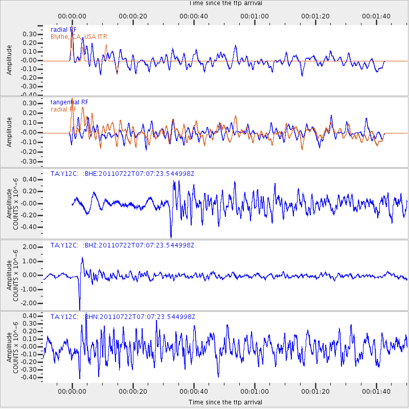
Y12C Blythe, CA, USA - Earthquake Result Viewer
*The percent match for this event was below the threshold and hence no stack was calculated.
| Earthquake location: |
Fiji Islands Region |
| Earthquake latitude/longitude: |
-20.3/-178.6 |
| Earthquake time(UTC): |
2011/07/22 (203) 06:56:40 GMT |
| Earthquake Depth: |
612 km |
| Earthquake Magnitude: |
5.9 MB, 6.0 MW, 5.9 MW |
| Earthquake Catalog/Contributor: |
WHDF/NEIC |
|
| Network: |
TA USArray Transportable Network (new EarthScope stations) |
| Station: |
Y12C Blythe, CA, USA |
| Lat/Lon: |
33.75 N/114.52 W |
| Elevation: |
196 m |
|
| Distance: |
81.3 deg |
| Az: |
49.288 deg |
| Baz: |
238.628 deg |
| Ray Param: |
$rayparam |
*The percent match for this event was below the threshold and hence was not used in the summary stack. |
|
| Radial Match: |
66.39827 % |
| Radial Bump: |
400 |
| Transverse Match: |
65.90208 % |
| Transverse Bump: |
400 |
| SOD ConfigId: |
401841 |
| Insert Time: |
2011-12-21 07:18:21.133 +0000 |
| GWidth: |
2.5 |
| Max Bumps: |
400 |
| Tol: |
0.001 |
|
Signal To Noise
| Channel | StoN | STA | LTA |
| TA:Y12C: :BHZ:20110722T07:07:23.544998Z | 4.7380443 | 6.932248E-7 | 1.4631033E-7 |
| TA:Y12C: :BHN:20110722T07:07:23.544998Z | 2.2530606 | 1.6702162E-7 | 7.4130995E-8 |
| TA:Y12C: :BHE:20110722T07:07:23.544998Z | 2.9446862 | 1.9980541E-7 | 6.7852866E-8 |
| Arrivals |
| Ps | |
| PpPs | |
| PsPs/PpSs | |


