You are here: Home > Network List > TA - USArray Transportable Network (new EarthScope stations) Stations List
> Station 133A Hamilton Ranch, Breckenridge, TX, USA > Earthquake Result Viewer
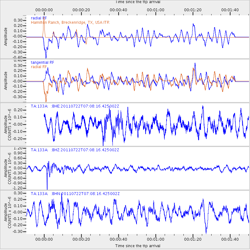
133A Hamilton Ranch, Breckenridge, TX, USA - Earthquake Result Viewer
*The percent match for this event was below the threshold and hence no stack was calculated.
| Earthquake location: |
Fiji Islands Region |
| Earthquake latitude/longitude: |
-20.3/-178.6 |
| Earthquake time(UTC): |
2011/07/22 (203) 06:56:40 GMT |
| Earthquake Depth: |
612 km |
| Earthquake Magnitude: |
5.9 MB, 6.0 MW, 5.9 MW |
| Earthquake Catalog/Contributor: |
WHDF/NEIC |
|
| Network: |
TA USArray Transportable Network (new EarthScope stations) |
| Station: |
133A Hamilton Ranch, Breckenridge, TX, USA |
| Lat/Lon: |
32.61 N/98.92 W |
| Elevation: |
418 m |
|
| Distance: |
92.5 deg |
| Az: |
56.215 deg |
| Baz: |
247.544 deg |
| Ray Param: |
$rayparam |
*The percent match for this event was below the threshold and hence was not used in the summary stack. |
|
| Radial Match: |
70.111336 % |
| Radial Bump: |
400 |
| Transverse Match: |
60.164936 % |
| Transverse Bump: |
400 |
| SOD ConfigId: |
401841 |
| Insert Time: |
2011-12-21 07:23:53.046 +0000 |
| GWidth: |
2.5 |
| Max Bumps: |
400 |
| Tol: |
0.001 |
|
Signal To Noise
| Channel | StoN | STA | LTA |
| TA:133A: :BHZ:20110722T07:08:16.425002Z | 2.301768 | 2.9572186E-7 | 1.2847596E-7 |
| TA:133A: :BHN:20110722T07:08:16.425002Z | 1.1949314 | 1.1055103E-7 | 9.251663E-8 |
| TA:133A: :BHE:20110722T07:08:16.425002Z | 1.2419368 | 1.04281526E-7 | 8.396685E-8 |
| Arrivals |
| Ps | |
| PpPs | |
| PsPs/PpSs | |


