You are here: Home > Network List > TA - USArray Transportable Network (new EarthScope stations) Stations List
> Station J01D Myrtle Point, OR, USA > Earthquake Result Viewer
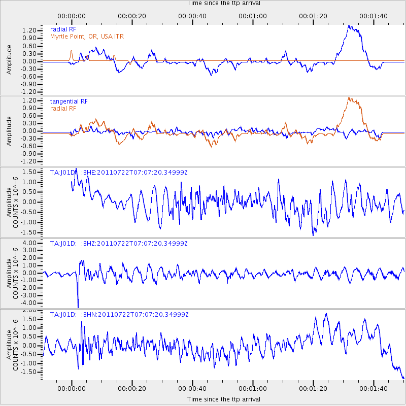
J01D Myrtle Point, OR, USA - Earthquake Result Viewer
*The percent match for this event was below the threshold and hence no stack was calculated.
| Earthquake location: |
Fiji Islands Region |
| Earthquake latitude/longitude: |
-20.3/-178.6 |
| Earthquake time(UTC): |
2011/07/22 (203) 06:56:40 GMT |
| Earthquake Depth: |
612 km |
| Earthquake Magnitude: |
5.9 MB, 6.0 MW, 5.9 MW |
| Earthquake Catalog/Contributor: |
WHDF/NEIC |
|
| Network: |
TA USArray Transportable Network (new EarthScope stations) |
| Station: |
J01D Myrtle Point, OR, USA |
| Lat/Lon: |
43.16 N/123.93 W |
| Elevation: |
131 m |
|
| Distance: |
80.7 deg |
| Az: |
37.221 deg |
| Baz: |
230.879 deg |
| Ray Param: |
$rayparam |
*The percent match for this event was below the threshold and hence was not used in the summary stack. |
|
| Radial Match: |
11.139034 % |
| Radial Bump: |
400 |
| Transverse Match: |
43.598225 % |
| Transverse Bump: |
400 |
| SOD ConfigId: |
401841 |
| Insert Time: |
2011-12-21 07:27:06.144 +0000 |
| GWidth: |
2.5 |
| Max Bumps: |
400 |
| Tol: |
0.001 |
|
Signal To Noise
| Channel | StoN | STA | LTA |
| TA:J01D: :BHZ:20110722T07:07:20.34999Z | 3.3792984 | 1.365935E-6 | 4.0420667E-7 |
| TA:J01D: :BHN:20110722T07:07:20.34999Z | 1.7961656 | 5.734295E-7 | 3.1925202E-7 |
| TA:J01D: :BHE:20110722T07:07:20.34999Z | 1.5108848 | 7.843931E-7 | 5.191614E-7 |
| Arrivals |
| Ps | |
| PpPs | |
| PsPs/PpSs | |


