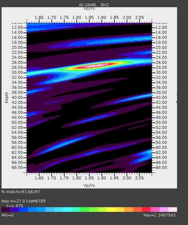
GAMB Gambell Broadband - Earthquake Result Viewer
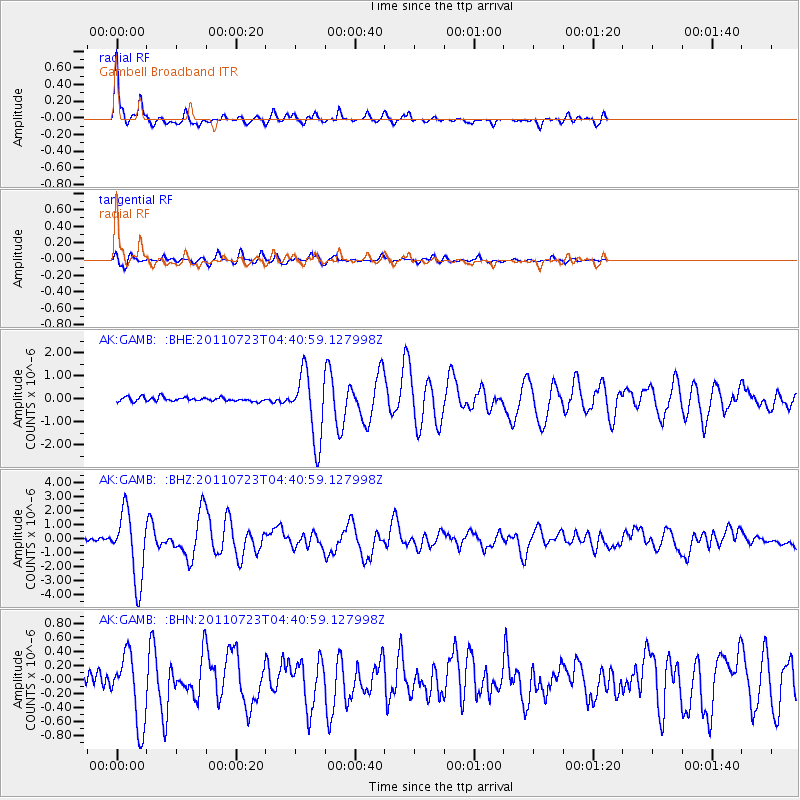
Earthquake location: Near East Coast Of Honshu, Japan
Earthquake latitude/longitude: 38.9/141.8
Earthquake time(UTC): 2011/07/23 (204) 04:34:24 GMT
Earthquake Depth: 41 km
Earthquake Magnitude: 5.9 MB, 5.9 MS, 6.4 MW, 6.3 MW
Earthquake Catalog/Contributor: WHDF/NEIC
Network: AK Alaska Regional Network
Station: GAMB Gambell Broadband
Lat/Lon: 63.78 N/171.70 W
Elevation: 10 m
Distance: 37.0 deg
Az: 32.394 deg
Baz: 250.218 deg
Ray Param: 0.076302186
Estimated Moho Depth: 27.0 km
Estimated Crust Vp/Vs: 1.88
Assumed Crust Vp: 6.24 km/s
Estimated Crust Vs: 3.328 km/s
Estimated Crust Poisson's Ratio: 0.30
Radial Match: 93.66397 %
Radial Bump: 292
Transverse Match: 78.44258 %
Transverse Bump: 400
SOD ConfigId: 405110
Insert Time: 2011-12-29 04:26:57.020 +0000
GWidth: 2.5
Max Bumps: 400
Tol: 0.001

Signal To Noise

ChannelStoNSTALTA
AK:GAMB: :BHZ:20110723T04:40:59.127998Z22.3916472.4183535E-61.0800248E-7
AK:GAMB: :BHN:20110723T04:40:59.127998Z5.8594725.0396136E-78.600799E-8
AK:GAMB: :BHE:20110723T04:40:59.127998Z16.8945431.4563649E-68.620328E-8
Arrivals
Ps4.0 SECOND
PpPs12 SECOND
PsPs/PpSs16 SECOND