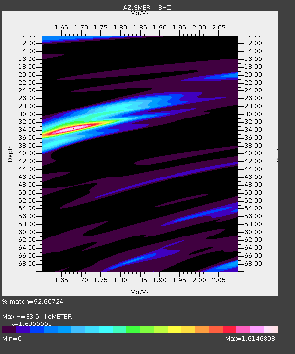
SMER AZ.SMER - Earthquake Result Viewer
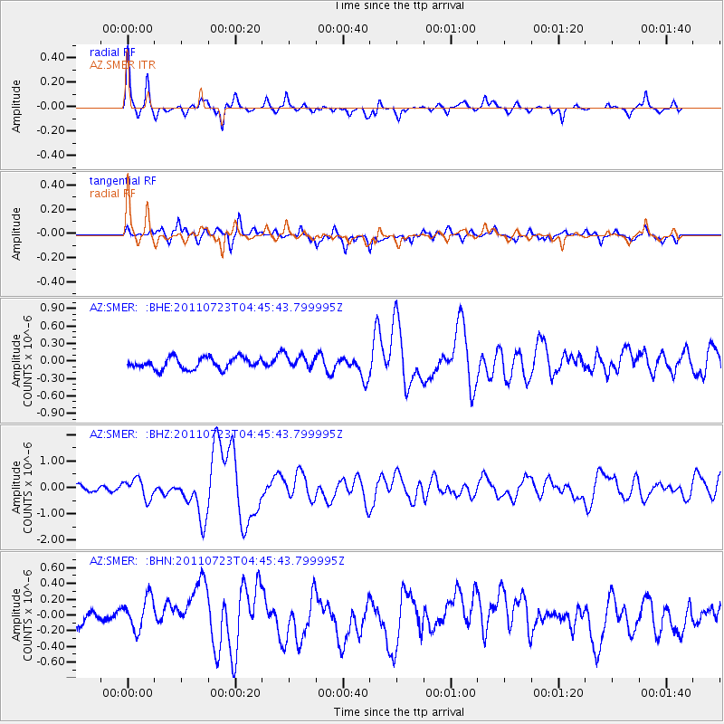
Earthquake location: Near East Coast Of Honshu, Japan
Earthquake latitude/longitude: 38.9/141.8
Earthquake time(UTC): 2011/07/23 (204) 04:34:24 GMT
Earthquake Depth: 41 km
Earthquake Magnitude: 5.9 MB, 5.9 MS, 6.4 MW, 6.3 MW
Earthquake Catalog/Contributor: WHDF/NEIC
Network: AZ ANZA Regional Network
Station: SMER AZ.SMER
Lat/Lon: 33.46 N/117.17 W
Elevation: 355 m
Distance: 77.4 deg
Az: 57.237 deg
Baz: 308.287 deg
Ray Param: 0.050297197
Estimated Moho Depth: 33.5 km
Estimated Crust Vp/Vs: 1.68
Assumed Crust Vp: 6.264 km/s
Estimated Crust Vs: 3.728 km/s
Estimated Crust Poisson's Ratio: 0.23
Radial Match: 92.60724 %
Radial Bump: 400
Transverse Match: 62.55214 %
Transverse Bump: 400
SOD ConfigId: 405110
Insert Time: 2011-12-29 04:31:49.908 +0000
GWidth: 2.5
Max Bumps: 400
Tol: 0.001

Signal To Noise

ChannelStoNSTALTA
AZ:SMER: :BHZ:20110723T04:45:43.799995Z3.22228863.7303604E-71.1576742E-7
AZ:SMER: :BHN:20110723T04:45:43.799995Z1.9144272.1854842E-71.1415865E-7
AZ:SMER: :BHE:20110723T04:45:43.799995Z1.12692991.0963262E-79.7284335E-8
Arrivals
Ps3.7 SECOND
PpPs14 SECOND
PsPs/PpSs18 SECOND