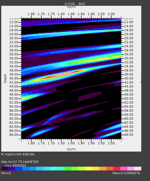
DGR Domenigoni Reservoir, California, USA - Earthquake Result Viewer
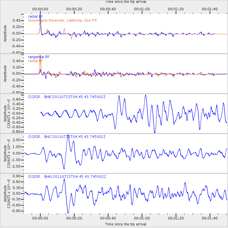
Earthquake location: Near East Coast Of Honshu, Japan
Earthquake latitude/longitude: 38.9/141.8
Earthquake time(UTC): 2011/07/23 (204) 04:34:24 GMT
Earthquake Depth: 41 km
Earthquake Magnitude: 5.9 MB, 5.9 MS, 6.4 MW, 6.3 MW
Earthquake Catalog/Contributor: WHDF/NEIC
Network: CI Caltech Regional Seismic Network
Station: DGR Domenigoni Reservoir, California, USA
Lat/Lon: 33.65 N/117.01 W
Elevation: 609 m
Distance: 77.4 deg
Az: 56.997 deg
Baz: 308.323 deg
Ray Param: 0.050306164
Estimated Moho Depth: 37.75 km
Estimated Crust Vp/Vs: 1.81
Assumed Crust Vp: 6.264 km/s
Estimated Crust Vs: 3.47 km/s
Estimated Crust Poisson's Ratio: 0.28
Radial Match: 94.448166 %
Radial Bump: 307
Transverse Match: 75.59194 %
Transverse Bump: 400
SOD ConfigId: 405110
Insert Time: 2011-12-29 04:34:25.582 +0000
GWidth: 2.5
Max Bumps: 400
Tol: 0.001

Signal To Noise

ChannelStoNSTALTA
CI:DGR: :BHZ:20110723T04:45:43.745002Z6.2223296.5146E-71.04697136E-7
CI:DGR: :BHN:20110723T04:45:43.745002Z2.67165952.2133213E-78.284444E-8
CI:DGR: :BHE:20110723T04:45:43.745002Z1.5476131.4359392E-79.278412E-8
Arrivals
Ps5.0 SECOND
PpPs16 SECOND
PsPs/PpSs21 SECOND