You are here: Home > Network List > CI - Caltech Regional Seismic Network Stations List
> Station RCT Rector, Visalia, CA, USA > Earthquake Result Viewer
RCT Rector, Visalia, CA, USA - Earthquake Result Viewer
| Earthquake location: |
Near East Coast Of Honshu, Japan |
| Earthquake latitude/longitude: |
38.9/141.8 |
| Earthquake time(UTC): |
2011/07/23 (204) 04:34:24 GMT |
| Earthquake Depth: |
41 km |
| Earthquake Magnitude: |
5.9 MB, 5.9 MS, 6.4 MW, 6.3 MW |
| Earthquake Catalog/Contributor: |
WHDF/NEIC |
|
| Network: |
CI Caltech Regional Seismic Network |
| Station: |
RCT Rector, Visalia, CA, USA |
| Lat/Lon: |
36.31 N/119.24 W |
| Elevation: |
107 m |
|
| Distance: |
74.3 deg |
| Az: |
55.986 deg |
| Baz: |
306.8 deg |
| Ray Param: |
0.05236069 |
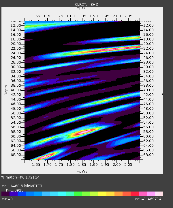
| Estimated Moho Depth: |
68.5 km |
| Estimated Crust Vp/Vs: |
1.69 |
| Assumed Crust Vp: |
6.291 km/s |
| Estimated Crust Vs: |
3.717 km/s |
| Estimated Crust Poisson's Ratio: |
0.23 |
|
| Radial Match: |
90.172134 % |
| Radial Bump: |
400 |
| Transverse Match: |
73.493324 % |
| Transverse Bump: |
400 |
| SOD ConfigId: |
405110 |
| Insert Time: |
2011-12-29 04:35:55.566 +0000 |
| GWidth: |
2.5 |
| Max Bumps: |
400 |
| Tol: |
0.001 |
|
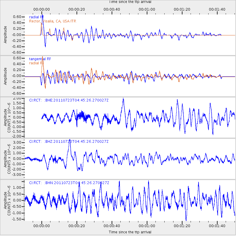
Signal To Noise
| Channel | StoN | STA | LTA |
| CI:RCT: :BHZ:20110723T04:45:26.270027Z | 5.0527263 | 8.2860737E-7 | 1.6399213E-7 |
| CI:RCT: :BHN:20110723T04:45:26.270027Z | 1.5219009 | 3.3234664E-7 | 2.1837602E-7 |
| CI:RCT: :BHE:20110723T04:45:26.270027Z | 1.9322882 | 6.2025646E-7 | 3.2099584E-7 |
| Arrivals |
| Ps | 7.8 SECOND |
| PpPs | 28 SECOND |
| PsPs/PpSs | 36 SECOND |


