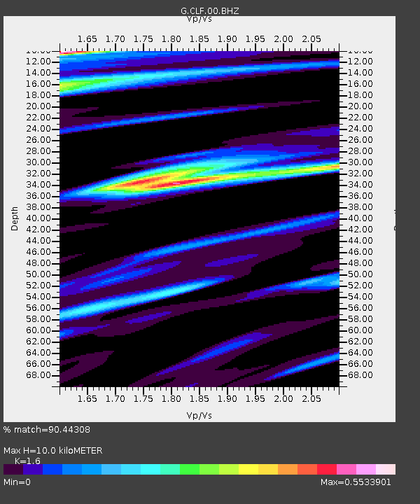
CLF Chambon la Foret observatory, France - Earthquake Result Viewer
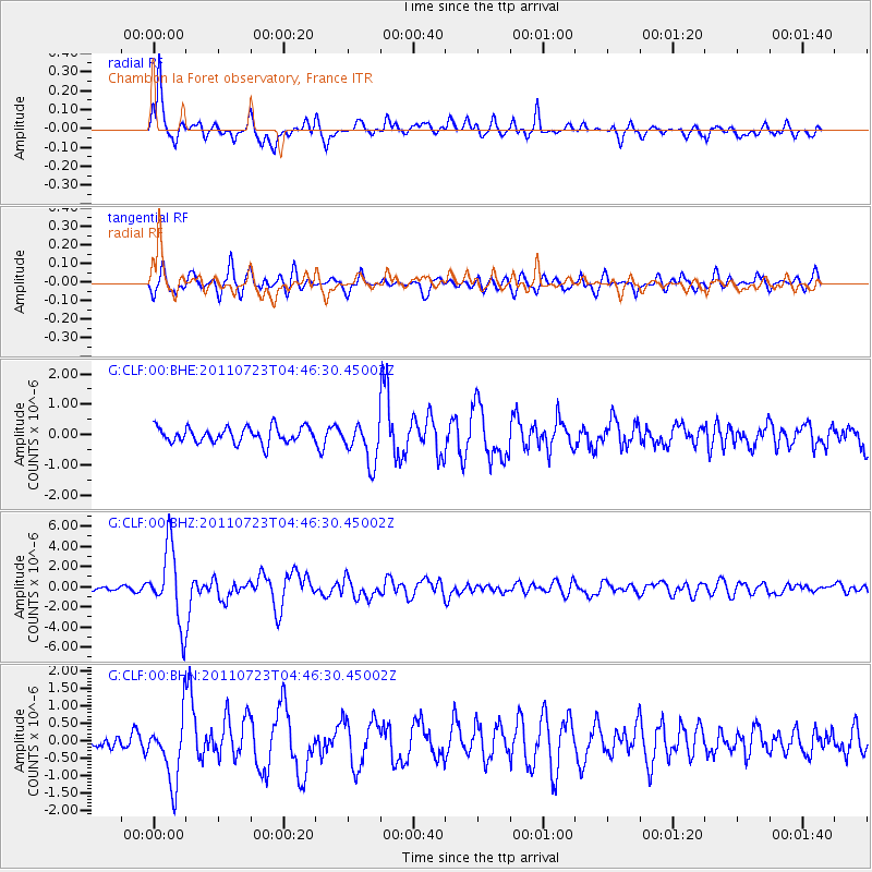
Earthquake location: Near East Coast Of Honshu, Japan
Earthquake latitude/longitude: 38.9/141.8
Earthquake time(UTC): 2011/07/23 (204) 04:34:24 GMT
Earthquake Depth: 41 km
Earthquake Magnitude: 5.9 MB, 5.9 MS, 6.4 MW, 6.3 MW
Earthquake Catalog/Contributor: WHDF/NEIC
Network: G GEOSCOPE
Station: CLF Chambon la Foret observatory, France
Lat/Lon: 48.03 N/2.26 E
Elevation: 145 m
Distance: 86.3 deg
Az: 334.126 deg
Baz: 30.483 deg
Ray Param: 0.044104386
Estimated Moho Depth: 10.0 km
Estimated Crust Vp/Vs: 1.60
Assumed Crust Vp: 6.12 km/s
Estimated Crust Vs: 3.825 km/s
Estimated Crust Poisson's Ratio: 0.18
Radial Match: 90.44308 %
Radial Bump: 400
Transverse Match: 76.804054 %
Transverse Bump: 400
SOD ConfigId: 405110
Insert Time: 2011-12-29 04:38:04.765 +0000
GWidth: 2.5
Max Bumps: 400
Tol: 0.001

Signal To Noise

ChannelStoNSTALTA
G:CLF:00:BHZ:20110723T04:46:30.45002Z13.9581593.7001892E-62.6509147E-7
G:CLF:00:BHN:20110723T04:46:30.45002Z3.49584279.357537E-72.6767614E-7
G:CLF:00:BHE:20110723T04:46:30.45002Z2.63232026.7062587E-72.5476606E-7
Arrivals
Ps1.0 SECOND
PpPs4.2 SECOND
PsPs/PpSs5.2 SECOND