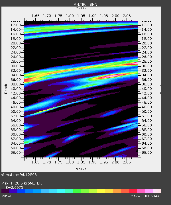
TIP Timpagrande, Italy - Earthquake Result Viewer
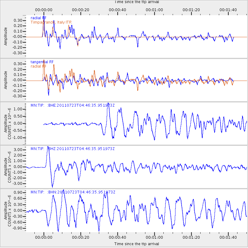
Earthquake location: Near East Coast Of Honshu, Japan
Earthquake latitude/longitude: 38.9/141.8
Earthquake time(UTC): 2011/07/23 (204) 04:34:24 GMT
Earthquake Depth: 41 km
Earthquake Magnitude: 5.9 MB, 5.9 MS, 6.4 MW, 6.3 MW
Earthquake Catalog/Contributor: WHDF/NEIC
Network: MN MEDNET Project
Station: TIP Timpagrande, Italy
Lat/Lon: 39.18 N/16.76 E
Elevation: 789 m
Distance: 87.4 deg
Az: 320.44 deg
Baz: 39.748 deg
Ray Param: 0.04328383
Estimated Moho Depth: 28.5 km
Estimated Crust Vp/Vs: 2.10
Assumed Crust Vp: 6.1 km/s
Estimated Crust Vs: 2.908 km/s
Estimated Crust Poisson's Ratio: 0.35
Radial Match: 96.12805 %
Radial Bump: 400
Transverse Match: 90.29426 %
Transverse Bump: 400
SOD ConfigId: 405110
Insert Time: 2011-12-29 04:43:20.435 +0000
GWidth: 2.5
Max Bumps: 400
Tol: 0.001

Signal To Noise

ChannelStoNSTALTA
MN:TIP: :BHZ:20110723T04:46:35.951973Z34.1828731.9913055E-65.8254482E-8
MN:TIP: :BHN:20110723T04:46:35.951973Z10.4504333.8229783E-73.658201E-8
MN:TIP: :BHE:20110723T04:46:35.951973Z12.1398785.474309E-74.509361E-8
Arrivals
Ps5.2 SECOND
PpPs14 SECOND
PsPs/PpSs19 SECOND