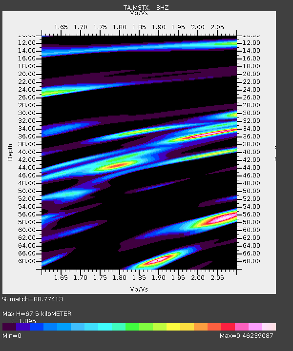
MSTX Muleshoe, TX, USA - Earthquake Result Viewer

Earthquake location: Near East Coast Of Honshu, Japan
Earthquake latitude/longitude: 38.9/141.8
Earthquake time(UTC): 2011/07/23 (204) 04:34:24 GMT
Earthquake Depth: 41 km
Earthquake Magnitude: 5.9 MB, 5.9 MS, 6.4 MW, 6.3 MW
Earthquake Catalog/Contributor: WHDF/NEIC
Network: TA USArray Transportable Network (new EarthScope stations)
Station: MSTX Muleshoe, TX, USA
Lat/Lon: 33.97 N/102.77 W
Elevation: 1167 m
Distance: 86.0 deg
Az: 48.805 deg
Baz: 315.047 deg
Ray Param: 0.04429253
Estimated Moho Depth: 67.5 km
Estimated Crust Vp/Vs: 1.89
Assumed Crust Vp: 6.129 km/s
Estimated Crust Vs: 3.234 km/s
Estimated Crust Poisson's Ratio: 0.31
Radial Match: 88.77413 %
Radial Bump: 400
Transverse Match: 79.285645 %
Transverse Bump: 400
SOD ConfigId: 405110
Insert Time: 2011-12-29 04:47:16.640 +0000
GWidth: 2.5
Max Bumps: 400
Tol: 0.001

Signal To Noise

ChannelStoNSTALTA
TA:MSTX: :BHZ:20110723T04:46:29.149971Z6.17049741.0260387E-61.6628137E-7
TA:MSTX: :BHN:20110723T04:46:29.149971Z2.17630582.454428E-71.1277956E-7
TA:MSTX: :BHE:20110723T04:46:29.149971Z3.3710844.4518256E-71.3205917E-7
Arrivals
Ps10 SECOND
PpPs31 SECOND
PsPs/PpSs41 SECOND