You are here: Home > Network List > NE - New England Seismic Network Stations List
> Station WVL Waterville, ME, USA > Earthquake Result Viewer
WVL Waterville, ME, USA - Earthquake Result Viewer
| Earthquake location: |
Yellow Sea |
| Earthquake latitude/longitude: |
36.9/124.6 |
| Earthquake time(UTC): |
2014/03/31 (090) 19:48:35 GMT |
| Earthquake Depth: |
13 km |
| Earthquake Magnitude: |
4.8 MW |
| Earthquake Catalog/Contributor: |
ISC/ISC |
|
| Network: |
NE New England Seismic Network |
| Station: |
WVL Waterville, ME, USA |
| Lat/Lon: |
44.56 N/69.66 W |
| Elevation: |
50 m |
|
| Distance: |
97.9 deg |
| Az: |
10.214 deg |
| Baz: |
348.537 deg |
| Ray Param: |
0.040086143 |
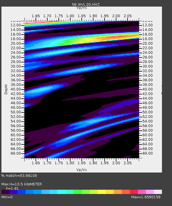
| Estimated Moho Depth: |
10.5 km |
| Estimated Crust Vp/Vs: |
1.61 |
| Assumed Crust Vp: |
6.419 km/s |
| Estimated Crust Vs: |
3.987 km/s |
| Estimated Crust Poisson's Ratio: |
0.19 |
|
| Radial Match: |
83.86108 % |
| Radial Bump: |
400 |
| Transverse Match: |
72.85409 % |
| Transverse Bump: |
342 |
| SOD ConfigId: |
3390531 |
| Insert Time: |
2019-04-10 23:26:20.981 +0000 |
| GWidth: |
2.5 |
| Max Bumps: |
400 |
| Tol: |
0.001 |
|

Signal To Noise
| Channel | StoN | STA | LTA |
| NE:WVL:00:HHZ:20140331T20:01:39.043975Z | 2.124457 | 3.4702625E-6 | 1.6334823E-6 |
| NE:WVL:00:HH1:20140331T20:01:39.043975Z | 1.4693438 | 1.8062724E-6 | 1.2293056E-6 |
| NE:WVL:00:HH2:20140331T20:01:39.043975Z | 1.6481792 | 1.6720908E-6 | 1.0145078E-6 |
| Arrivals |
| Ps | 1.0 SECOND |
| PpPs | 4.2 SECOND |
| PsPs/PpSs | 5.2 SECOND |


