You are here: Home > Network List > TA - USArray Transportable Network (new EarthScope stations) Stations List
> Station O32A Brockman Farm, Red Cloud, NE, USA > Earthquake Result Viewer
O32A Brockman Farm, Red Cloud, NE, USA - Earthquake Result Viewer
| Earthquake location: |
Near East Coast Of Honshu, Japan |
| Earthquake latitude/longitude: |
38.9/141.8 |
| Earthquake time(UTC): |
2011/07/23 (204) 04:34:24 GMT |
| Earthquake Depth: |
41 km |
| Earthquake Magnitude: |
5.9 MB, 5.9 MS, 6.4 MW, 6.3 MW |
| Earthquake Catalog/Contributor: |
WHDF/NEIC |
|
| Network: |
TA USArray Transportable Network (new EarthScope stations) |
| Station: |
O32A Brockman Farm, Red Cloud, NE, USA |
| Lat/Lon: |
40.26 N/98.28 W |
| Elevation: |
579 m |
|
| Distance: |
84.0 deg |
| Az: |
41.836 deg |
| Baz: |
317.145 deg |
| Ray Param: |
0.04573917 |
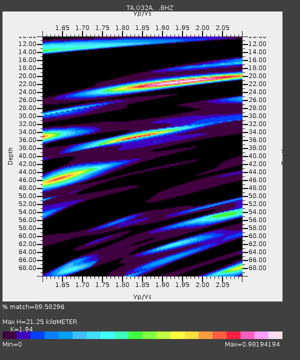
| Estimated Moho Depth: |
21.25 km |
| Estimated Crust Vp/Vs: |
1.94 |
| Assumed Crust Vp: |
6.53 km/s |
| Estimated Crust Vs: |
3.366 km/s |
| Estimated Crust Poisson's Ratio: |
0.32 |
|
| Radial Match: |
89.58296 % |
| Radial Bump: |
400 |
| Transverse Match: |
76.31502 % |
| Transverse Bump: |
400 |
| SOD ConfigId: |
405110 |
| Insert Time: |
2011-12-29 04:49:59.176 +0000 |
| GWidth: |
2.5 |
| Max Bumps: |
400 |
| Tol: |
0.001 |
|

Signal To Noise
| Channel | StoN | STA | LTA |
| TA:O32A: :BHZ:20110723T04:46:19.000007Z | 13.395871 | 1.1325545E-6 | 8.454504E-8 |
| TA:O32A: :BHN:20110723T04:46:19.000007Z | 3.0289795 | 4.007431E-7 | 1.32303E-7 |
| TA:O32A: :BHE:20110723T04:46:19.000007Z | 2.1856782 | 3.537542E-7 | 1.6185099E-7 |
| Arrivals |
| Ps | 3.1 SECOND |
| PpPs | 9.3 SECOND |
| PsPs/PpSs | 12 SECOND |


