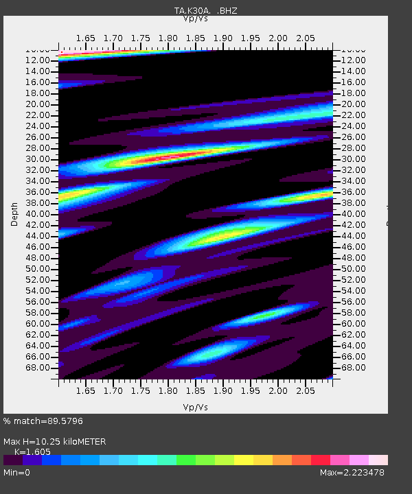
K30A Basset, NE, USA - Earthquake Result Viewer

Earthquake location: Near East Coast Of Honshu, Japan
Earthquake latitude/longitude: 38.9/141.8
Earthquake time(UTC): 2011/07/23 (204) 04:34:24 GMT
Earthquake Depth: 41 km
Earthquake Magnitude: 5.9 MB, 5.9 MS, 6.4 MW, 6.3 MW
Earthquake Catalog/Contributor: WHDF/NEIC
Network: TA USArray Transportable Network (new EarthScope stations)
Station: K30A Basset, NE, USA
Lat/Lon: 42.67 N/99.61 W
Elevation: 712 m
Distance: 81.5 deg
Az: 40.904 deg
Baz: 316.145 deg
Ray Param: 0.047450434
Estimated Moho Depth: 10.25 km
Estimated Crust Vp/Vs: 1.61
Assumed Crust Vp: 6.53 km/s
Estimated Crust Vs: 4.069 km/s
Estimated Crust Poisson's Ratio: 0.18
Radial Match: 89.5796 %
Radial Bump: 400
Transverse Match: 79.49171 %
Transverse Bump: 400
SOD ConfigId: 405110
Insert Time: 2011-12-29 04:50:12.431 +0000
GWidth: 2.5
Max Bumps: 400
Tol: 0.001

Signal To Noise

ChannelStoNSTALTA
TA:K30A: :BHZ:20110723T04:46:06.375007Z16.3108921.6265649E-69.972263E-8
TA:K30A: :BHN:20110723T04:46:06.375007Z3.66597277.5333173E-72.0549301E-7
TA:K30A: :BHE:20110723T04:46:06.375007Z2.7491396.8657675E-72.4974247E-7
Arrivals
Ps1.0 SECOND
PpPs4.0 SECOND
PsPs/PpSs4.9 SECOND