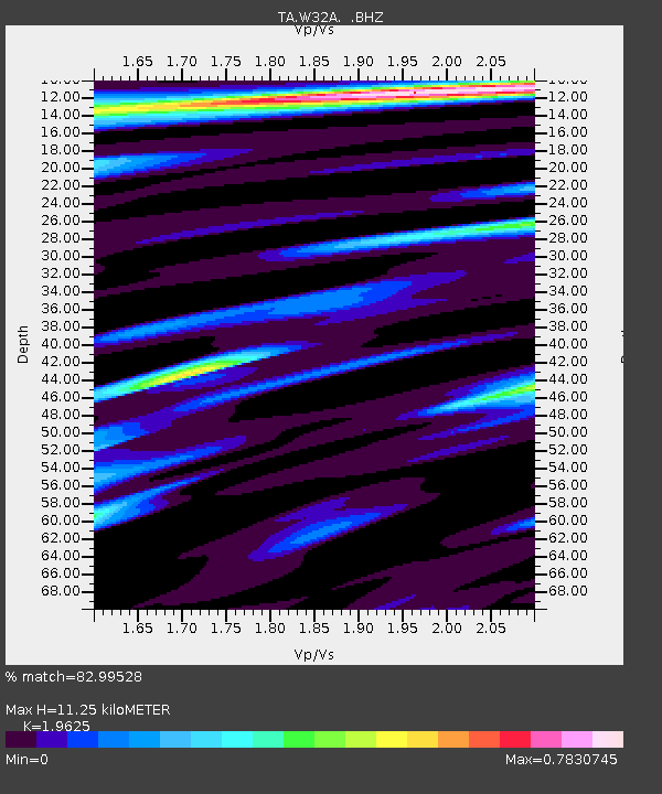
W32A Sentinel, OK, USA - Earthquake Result Viewer

Earthquake location: Near East Coast Of Honshu, Japan
Earthquake latitude/longitude: 38.9/141.8
Earthquake time(UTC): 2011/07/23 (204) 04:34:24 GMT
Earthquake Depth: 41 km
Earthquake Magnitude: 5.9 MB, 5.9 MS, 6.4 MW, 6.3 MW
Earthquake Catalog/Contributor: WHDF/NEIC
Network: TA USArray Transportable Network (new EarthScope stations)
Station: W32A Sentinel, OK, USA
Lat/Lon: 35.12 N/99.25 W
Elevation: 494 m
Distance: 87.2 deg
Az: 45.908 deg
Baz: 316.867 deg
Ray Param: 0.043426014
Estimated Moho Depth: 11.25 km
Estimated Crust Vp/Vs: 1.96
Assumed Crust Vp: 6.315 km/s
Estimated Crust Vs: 3.218 km/s
Estimated Crust Poisson's Ratio: 0.32
Radial Match: 82.99528 %
Radial Bump: 400
Transverse Match: 74.549324 %
Transverse Bump: 400
SOD ConfigId: 405110
Insert Time: 2011-12-29 04:52:19.803 +0000
GWidth: 2.5
Max Bumps: 400
Tol: 0.001

Signal To Noise

ChannelStoNSTALTA
TA:W32A: :BHZ:20110723T04:46:34.974983Z8.7763241.1478717E-61.3079185E-7
TA:W32A: :BHN:20110723T04:46:34.974983Z1.636022.9421565E-71.7983623E-7
TA:W32A: :BHE:20110723T04:46:34.974983Z2.14668182.7192786E-71.2667357E-7
Arrivals
Ps1.7 SECOND
PpPs5.2 SECOND
PsPs/PpSs6.9 SECOND