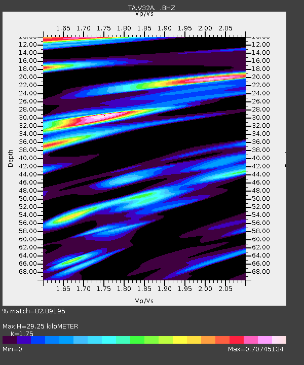
V32A Arapaho, OK, USA - Earthquake Result Viewer

Earthquake location: Near East Coast Of Honshu, Japan
Earthquake latitude/longitude: 38.9/141.8
Earthquake time(UTC): 2011/07/23 (204) 04:34:24 GMT
Earthquake Depth: 41 km
Earthquake Magnitude: 5.9 MB, 5.9 MS, 6.4 MW, 6.3 MW
Earthquake Catalog/Contributor: WHDF/NEIC
Network: TA USArray Transportable Network (new EarthScope stations)
Station: V32A Arapaho, OK, USA
Lat/Lon: 35.72 N/99.04 W
Elevation: 533 m
Distance: 86.9 deg
Az: 45.38 deg
Baz: 316.956 deg
Ray Param: 0.043661527
Estimated Moho Depth: 29.25 km
Estimated Crust Vp/Vs: 1.75
Assumed Crust Vp: 6.315 km/s
Estimated Crust Vs: 3.609 km/s
Estimated Crust Poisson's Ratio: 0.26
Radial Match: 82.89195 %
Radial Bump: 400
Transverse Match: 55.369442 %
Transverse Bump: 400
SOD ConfigId: 405110
Insert Time: 2011-12-29 04:52:32.930 +0000
GWidth: 2.5
Max Bumps: 400
Tol: 0.001

Signal To Noise

ChannelStoNSTALTA
TA:V32A: :BHZ:20110723T04:46:33.399971Z5.0418431.4510078E-62.8779314E-7
TA:V32A: :BHN:20110723T04:46:33.399971Z1.60183024.4808823E-72.7973516E-7
TA:V32A: :BHE:20110723T04:46:33.399971Z1.21578544.0735878E-73.3505816E-7
Arrivals
Ps3.6 SECOND
PpPs12 SECOND
PsPs/PpSs16 SECOND