You are here: Home > Network List > TA - USArray Transportable Network (new EarthScope stations) Stations List
> Station V33A Lossen Ranch, Watonga, OK, USA > Earthquake Result Viewer
V33A Lossen Ranch, Watonga, OK, USA - Earthquake Result Viewer

| Earthquake location: |
Near East Coast Of Honshu, Japan |
| Earthquake latitude/longitude: |
38.9/141.8 |
| Earthquake time(UTC): |
2011/07/23 (204) 04:34:24 GMT |
| Earthquake Depth: |
41 km |
| Earthquake Magnitude: |
5.9 MB, 5.9 MS, 6.4 MW, 6.3 MW |
| Earthquake Catalog/Contributor: |
WHDF/NEIC |
|
| Network: |
TA USArray Transportable Network (new EarthScope stations) |
| Station: |
V33A Lossen Ranch, Watonga, OK, USA |
| Lat/Lon: |
35.82 N/98.29 W |
| Elevation: |
420 m |
|
| Distance: |
87.2 deg |
| Az: |
44.859 deg |
| Baz: |
317.37 deg |
| Ray Param: |
0.04340895 |
| Estimated Moho Depth: |
17.0 km |
| Estimated Crust Vp/Vs: |
2.09 |
| Assumed Crust Vp: |
6.315 km/s |
| Estimated Crust Vs: |
3.018 km/s |
| Estimated Crust Poisson's Ratio: |
0.35 |
|
| Radial Match: |
81.76819 % |
| Radial Bump: |
400 |
| Transverse Match: |
68.88331 % |
| Transverse Bump: |
298 |
| SOD ConfigId: |
405110 |
| Insert Time: |
2011-12-29 04:52:42.438 +0000 |
| GWidth: |
2.5 |
| Max Bumps: |
400 |
| Tol: |
0.001 |
|
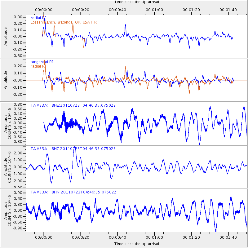
Signal To Noise
| Channel | StoN | STA | LTA |
| TA:V33A: :BHZ:20110723T04:46:35.07502Z | 8.11167 | 1.2804425E-6 | 1.5785191E-7 |
| TA:V33A: :BHN:20110723T04:46:35.07502Z | 1.1170602 | 2.8489484E-7 | 2.5503985E-7 |
| TA:V33A: :BHE:20110723T04:46:35.07502Z | 2.1244774 | 3.6040424E-7 | 1.6964373E-7 |
| Arrivals |
| Ps | 3.0 SECOND |
| PpPs | 8.2 SECOND |
| PsPs/PpSs | 11 SECOND |


