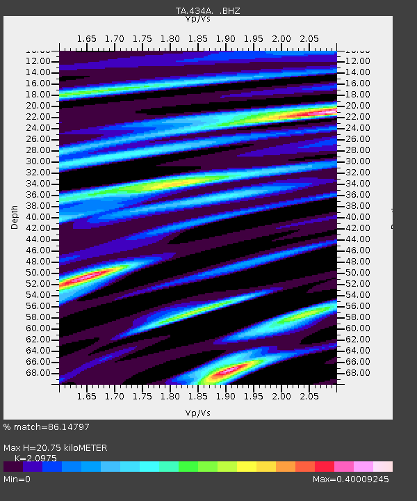
434A Burnet, TX, USA - Earthquake Result Viewer

Earthquake location: Near East Coast Of Honshu, Japan
Earthquake latitude/longitude: 38.9/141.8
Earthquake time(UTC): 2011/07/23 (204) 04:34:24 GMT
Earthquake Depth: 41 km
Earthquake Magnitude: 5.9 MB, 5.9 MS, 6.4 MW, 6.3 MW
Earthquake Catalog/Contributor: WHDF/NEIC
Network: TA USArray Transportable Network (new EarthScope stations)
Station: 434A Burnet, TX, USA
Lat/Lon: 30.81 N/98.27 W
Elevation: 462 m
Distance: 90.9 deg
Az: 48.228 deg
Baz: 317.434 deg
Ray Param: 0.041633304
Estimated Moho Depth: 20.75 km
Estimated Crust Vp/Vs: 2.10
Assumed Crust Vp: 6.498 km/s
Estimated Crust Vs: 3.098 km/s
Estimated Crust Poisson's Ratio: 0.35
Radial Match: 86.14797 %
Radial Bump: 318
Transverse Match: 66.970535 %
Transverse Bump: 400
SOD ConfigId: 405110
Insert Time: 2011-12-29 04:53:20.116 +0000
GWidth: 2.5
Max Bumps: 400
Tol: 0.001

Signal To Noise

ChannelStoNSTALTA
TA:434A: :BHZ:20110723T04:46:52.375007Z9.8797386.312484E-76.389324E-8
TA:434A: :BHN:20110723T04:46:52.375007Z2.63911991.5759632E-75.971548E-8
TA:434A: :BHE:20110723T04:46:52.375007Z2.60581851.327079E-75.092753E-8
Arrivals
Ps3.6 SECOND
PpPs9.7 SECOND
PsPs/PpSs13 SECOND