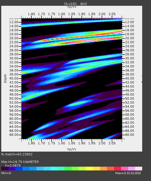
L02D Cave Junction, OR, USA - Earthquake Result Viewer
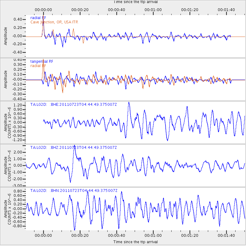
Earthquake location: Near East Coast Of Honshu, Japan
Earthquake latitude/longitude: 38.9/141.8
Earthquake time(UTC): 2011/07/23 (204) 04:34:24 GMT
Earthquake Depth: 41 km
Earthquake Magnitude: 5.9 MB, 5.9 MS, 6.4 MW, 6.3 MW
Earthquake Catalog/Contributor: WHDF/NEIC
Network: TA USArray Transportable Network (new EarthScope stations)
Station: L02D Cave Junction, OR, USA
Lat/Lon: 42.16 N/123.60 W
Elevation: 458 m
Distance: 68.2 deg
Az: 52.978 deg
Baz: 303.08 deg
Ray Param: 0.056404803
Estimated Moho Depth: 16.75 km
Estimated Crust Vp/Vs: 2.10
Assumed Crust Vp: 6.522 km/s
Estimated Crust Vs: 3.109 km/s
Estimated Crust Poisson's Ratio: 0.35
Radial Match: 83.22902 %
Radial Bump: 400
Transverse Match: 68.29592 %
Transverse Bump: 400
SOD ConfigId: 405110
Insert Time: 2011-12-29 04:53:32.928 +0000
GWidth: 2.5
Max Bumps: 400
Tol: 0.001

Signal To Noise

ChannelStoNSTALTA
TA:L02D: :BHZ:20110723T04:44:49.375007Z2.44851526.5139994E-72.6603877E-7
TA:L02D: :BHN:20110723T04:44:49.375007Z0.64866341.52387E-72.3492461E-7
TA:L02D: :BHE:20110723T04:44:49.375007Z1.67715872.7650205E-71.6486338E-7
Arrivals
Ps2.9 SECOND
PpPs7.7 SECOND
PsPs/PpSs11 SECOND