You are here: Home > Network List > UW - Pacific Northwest Regional Seismic Network Stations List
> Station MRBL Marblemount, WA, USA > Earthquake Result Viewer
MRBL Marblemount, WA, USA - Earthquake Result Viewer
*The percent match for this event was below the threshold and hence no stack was calculated.
| Earthquake location: |
Yellow Sea |
| Earthquake latitude/longitude: |
36.9/124.6 |
| Earthquake time(UTC): |
2014/03/31 (090) 19:48:35 GMT |
| Earthquake Depth: |
13 km |
| Earthquake Magnitude: |
4.8 MW |
| Earthquake Catalog/Contributor: |
ISC/ISC |
|
| Network: |
UW Pacific Northwest Regional Seismic Network |
| Station: |
MRBL Marblemount, WA, USA |
| Lat/Lon: |
48.52 N/121.48 W |
| Elevation: |
75 m |
|
| Distance: |
76.7 deg |
| Az: |
38.644 deg |
| Baz: |
311.195 deg |
| Ray Param: |
$rayparam |
*The percent match for this event was below the threshold and hence was not used in the summary stack. |
|
| Radial Match: |
60.501015 % |
| Radial Bump: |
400 |
| Transverse Match: |
51.264053 % |
| Transverse Bump: |
400 |
| SOD ConfigId: |
3390531 |
| Insert Time: |
2019-04-10 23:28:32.965 +0000 |
| GWidth: |
2.5 |
| Max Bumps: |
400 |
| Tol: |
0.001 |
|
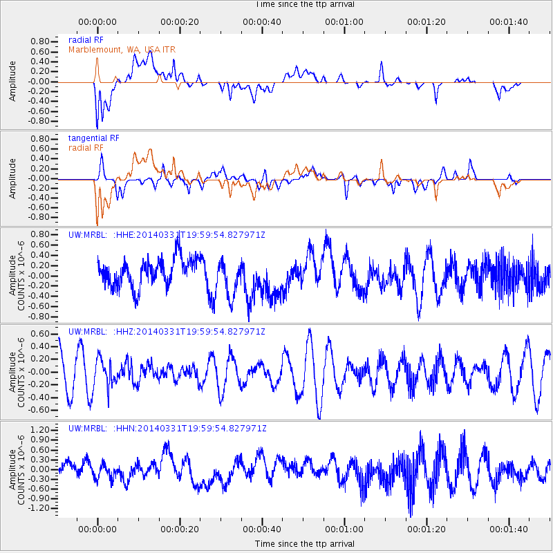
Signal To Noise
| Channel | StoN | STA | LTA |
| UW:MRBL: :HHZ:20140331T19:59:54.827971Z | 0.8083446 | 2.0685337E-7 | 2.558975E-7 |
| UW:MRBL: :HHN:20140331T19:59:54.827971Z | 0.8666356 | 2.1052934E-7 | 2.4292714E-7 |
| UW:MRBL: :HHE:20140331T19:59:54.827971Z | 1.3432028 | 3.587753E-7 | 2.6710435E-7 |
| Arrivals |
| Ps | |
| PpPs | |
| PsPs/PpSs | |


