You are here: Home > Network List > TA - USArray Transportable Network (new EarthScope stations) Stations List
> Station 337A Centerville, TX, USA > Earthquake Result Viewer
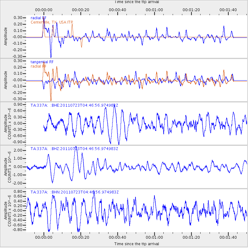
337A Centerville, TX, USA - Earthquake Result Viewer
*The percent match for this event was below the threshold and hence no stack was calculated.
| Earthquake location: |
Near East Coast Of Honshu, Japan |
| Earthquake latitude/longitude: |
38.9/141.8 |
| Earthquake time(UTC): |
2011/07/23 (204) 04:34:24 GMT |
| Earthquake Depth: |
41 km |
| Earthquake Magnitude: |
5.9 MB, 5.9 MS, 6.4 MW, 6.3 MW |
| Earthquake Catalog/Contributor: |
WHDF/NEIC |
|
| Network: |
TA USArray Transportable Network (new EarthScope stations) |
| Station: |
337A Centerville, TX, USA |
| Lat/Lon: |
31.32 N/95.89 W |
| Elevation: |
150 m |
|
| Distance: |
91.9 deg |
| Az: |
46.372 deg |
| Baz: |
318.704 deg |
| Ray Param: |
$rayparam |
*The percent match for this event was below the threshold and hence was not used in the summary stack. |
|
| Radial Match: |
65.097 % |
| Radial Bump: |
326 |
| Transverse Match: |
54.75732 % |
| Transverse Bump: |
395 |
| SOD ConfigId: |
405110 |
| Insert Time: |
2011-12-29 04:56:29.297 +0000 |
| GWidth: |
2.5 |
| Max Bumps: |
400 |
| Tol: |
0.001 |
|
Signal To Noise
| Channel | StoN | STA | LTA |
| TA:337A: :BHZ:20110723T04:46:56.974983Z | 5.2785735 | 9.0518296E-7 | 1.714825E-7 |
| TA:337A: :BHN:20110723T04:46:56.974983Z | 1.5587188 | 4.4943704E-7 | 2.8833747E-7 |
| TA:337A: :BHE:20110723T04:46:56.974983Z | 1.4379005 | 4.053629E-7 | 2.8191303E-7 |
| Arrivals |
| Ps | |
| PpPs | |
| PsPs/PpSs | |


