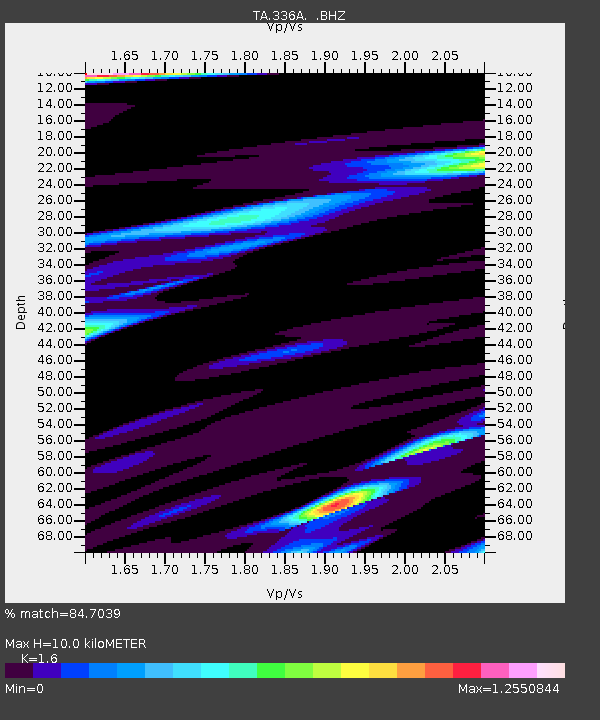
336A Riesel, TX, USA - Earthquake Result Viewer
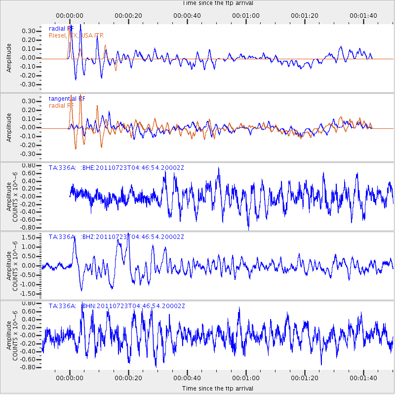
Earthquake location: Near East Coast Of Honshu, Japan
Earthquake latitude/longitude: 38.9/141.8
Earthquake time(UTC): 2011/07/23 (204) 04:34:24 GMT
Earthquake Depth: 41 km
Earthquake Magnitude: 5.9 MB, 5.9 MS, 6.4 MW, 6.3 MW
Earthquake Catalog/Contributor: WHDF/NEIC
Network: TA USArray Transportable Network (new EarthScope stations)
Station: 336A Riesel, TX, USA
Lat/Lon: 31.39 N/96.84 W
Elevation: 140 m
Distance: 91.3 deg
Az: 46.939 deg
Baz: 318.192 deg
Ray Param: 0.041604947
Estimated Moho Depth: 10.0 km
Estimated Crust Vp/Vs: 1.60
Assumed Crust Vp: 6.347 km/s
Estimated Crust Vs: 3.967 km/s
Estimated Crust Poisson's Ratio: 0.18
Radial Match: 84.7039 %
Radial Bump: 400
Transverse Match: 71.990265 %
Transverse Bump: 400
SOD ConfigId: 405110
Insert Time: 2011-12-29 04:56:42.308 +0000
GWidth: 2.5
Max Bumps: 400
Tol: 0.001

Signal To Noise

ChannelStoNSTALTA
TA:336A: :BHZ:20110723T04:46:54.20002Z9.3370227.157723E-77.6659596E-8
TA:336A: :BHN:20110723T04:46:54.20002Z1.60718662.7045797E-71.6828038E-7
TA:336A: :BHE:20110723T04:46:54.20002Z2.36463713.0735464E-71.2997963E-7
Arrivals
Ps1.0 SECOND
PpPs4.0 SECOND
PsPs/PpSs5.0 SECOND