You are here: Home > Network List > TA - USArray Transportable Network (new EarthScope stations) Stations List
> Station 338A Crockett, TX, USA > Earthquake Result Viewer
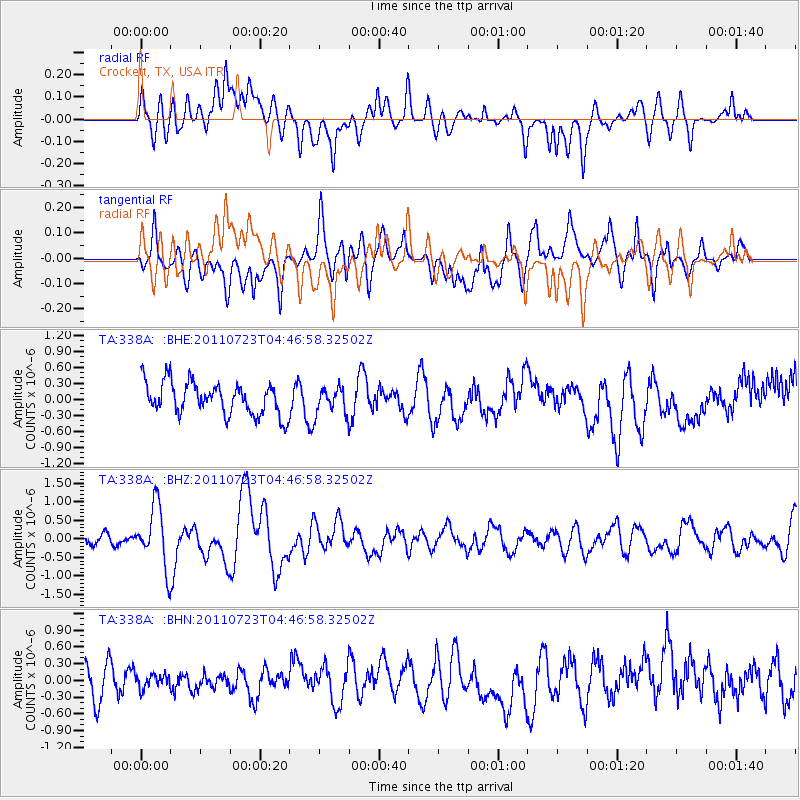
338A Crockett, TX, USA - Earthquake Result Viewer
*The percent match for this event was below the threshold and hence no stack was calculated.
| Earthquake location: |
Near East Coast Of Honshu, Japan |
| Earthquake latitude/longitude: |
38.9/141.8 |
| Earthquake time(UTC): |
2011/07/23 (204) 04:34:24 GMT |
| Earthquake Depth: |
41 km |
| Earthquake Magnitude: |
5.9 MB, 5.9 MS, 6.4 MW, 6.3 MW |
| Earthquake Catalog/Contributor: |
WHDF/NEIC |
|
| Network: |
TA USArray Transportable Network (new EarthScope stations) |
| Station: |
338A Crockett, TX, USA |
| Lat/Lon: |
31.36 N/95.31 W |
| Elevation: |
137 m |
|
| Distance: |
92.2 deg |
| Az: |
45.974 deg |
| Baz: |
319.016 deg |
| Ray Param: |
$rayparam |
*The percent match for this event was below the threshold and hence was not used in the summary stack. |
|
| Radial Match: |
60.186375 % |
| Radial Bump: |
400 |
| Transverse Match: |
56.057102 % |
| Transverse Bump: |
400 |
| SOD ConfigId: |
405110 |
| Insert Time: |
2011-12-29 04:57:07.252 +0000 |
| GWidth: |
2.5 |
| Max Bumps: |
400 |
| Tol: |
0.001 |
|
Signal To Noise
| Channel | StoN | STA | LTA |
| TA:338A: :BHZ:20110723T04:46:58.32502Z | 3.5341032 | 8.179214E-7 | 2.3143676E-7 |
| TA:338A: :BHN:20110723T04:46:58.32502Z | 0.3970357 | 1.2470117E-7 | 3.1408052E-7 |
| TA:338A: :BHE:20110723T04:46:58.32502Z | 0.7988189 | 2.4264418E-7 | 3.0375367E-7 |
| Arrivals |
| Ps | |
| PpPs | |
| PsPs/PpSs | |


