You are here: Home > Network List > TA - USArray Transportable Network (new EarthScope stations) Stations List
> Station 340A Bronson, TX, USA > Earthquake Result Viewer
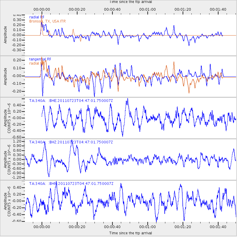
340A Bronson, TX, USA - Earthquake Result Viewer
*The percent match for this event was below the threshold and hence no stack was calculated.
| Earthquake location: |
Near East Coast Of Honshu, Japan |
| Earthquake latitude/longitude: |
38.9/141.8 |
| Earthquake time(UTC): |
2011/07/23 (204) 04:34:24 GMT |
| Earthquake Depth: |
41 km |
| Earthquake Magnitude: |
5.9 MB, 5.9 MS, 6.4 MW, 6.3 MW |
| Earthquake Catalog/Contributor: |
WHDF/NEIC |
|
| Network: |
TA USArray Transportable Network (new EarthScope stations) |
| Station: |
340A Bronson, TX, USA |
| Lat/Lon: |
31.42 N/93.89 W |
| Elevation: |
57 m |
|
| Distance: |
93.0 deg |
| Az: |
45.012 deg |
| Baz: |
319.796 deg |
| Ray Param: |
$rayparam |
*The percent match for this event was below the threshold and hence was not used in the summary stack. |
|
| Radial Match: |
65.857796 % |
| Radial Bump: |
400 |
| Transverse Match: |
63.107117 % |
| Transverse Bump: |
400 |
| SOD ConfigId: |
405110 |
| Insert Time: |
2011-12-29 04:57:07.770 +0000 |
| GWidth: |
2.5 |
| Max Bumps: |
400 |
| Tol: |
0.001 |
|
Signal To Noise
| Channel | StoN | STA | LTA |
| TA:340A: :BHZ:20110723T04:47:01.750007Z | 3.0277863 | 6.621278E-7 | 2.186838E-7 |
| TA:340A: :BHN:20110723T04:47:01.750007Z | 1.0423851 | 1.9103022E-7 | 1.8326261E-7 |
| TA:340A: :BHE:20110723T04:47:01.750007Z | 0.81365293 | 1.7848453E-7 | 2.19362E-7 |
| Arrivals |
| Ps | |
| PpPs | |
| PsPs/PpSs | |


