You are here: Home > Network List > 6D - Telica Seismic and Deformation Network Stations List
> Station TBHS TBHS > Earthquake Result Viewer
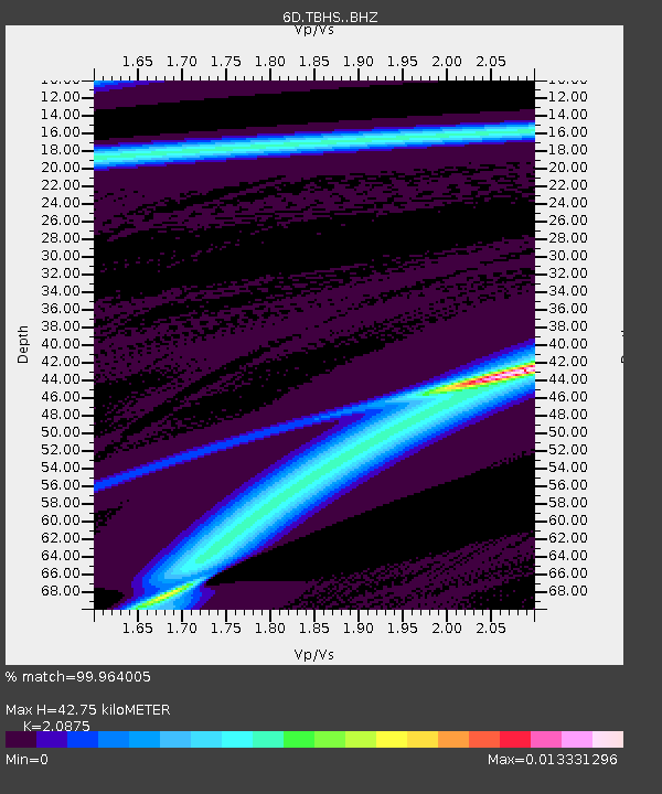
TBHS TBHS - Earthquake Result Viewer
| Earthquake location: |
Southern Mid-Atlantic Ridge |
| Earthquake latitude/longitude: |
-46.8/-10.6 |
| Earthquake time(UTC): |
2014/04/01 (091) 23:13:05 GMT |
| Earthquake Depth: |
10 km |
| Earthquake Magnitude: |
5.6 MW |
| Earthquake Catalog/Contributor: |
ISC/ISC |
|
| Network: |
6D Telica Seismic and Deformation Network |
| Station: |
TBHS TBHS |
| Lat/Lon: |
12.62 N/86.86 W |
| Elevation: |
535 m |
|
| Distance: |
89.9 deg |
| Az: |
288.524 deg |
| Baz: |
138.143 deg |
| Ray Param: |
0.041711323 |
| Estimated Moho Depth: |
42.75 km |
| Estimated Crust Vp/Vs: |
2.09 |
| Assumed Crust Vp: |
6.438 km/s |
| Estimated Crust Vs: |
3.084 km/s |
| Estimated Crust Poisson's Ratio: |
0.35 |
|
| Radial Match: |
99.964005 % |
| Radial Bump: |
6 |
| Transverse Match: |
99.96801 % |
| Transverse Bump: |
6 |
| SOD ConfigId: |
3390531 |
| Insert Time: |
2019-04-10 23:29:44.823 +0000 |
| GWidth: |
2.5 |
| Max Bumps: |
400 |
| Tol: |
0.001 |
|

Signal To Noise
| Channel | StoN | STA | LTA |
| 6D:TBHS: :BHZ:20140401T23:25:33.000017Z | 0.33517304 | 1.9121042E-6 | 5.704827E-6 |
| 6D:TBHS: :BHN:20140401T23:25:33.000017Z | 0.9223495 | 2.1063478E-7 | 2.2836764E-7 |
| 6D:TBHS: :BHE:20140401T23:25:33.000017Z | 0.7077176 | 4.6521095E-6 | 6.5733975E-6 |
| Arrivals |
| Ps | 7.3 SECOND |
| PpPs | 20 SECOND |
| PsPs/PpSs | 27 SECOND |


