You are here: Home > Network List > TA - USArray Transportable Network (new EarthScope stations) Stations List
> Station Y37A Hugo, OK, USA > Earthquake Result Viewer
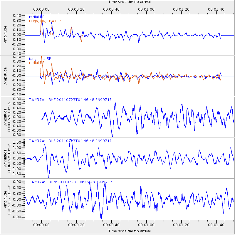
Y37A Hugo, OK, USA - Earthquake Result Viewer
*The percent match for this event was below the threshold and hence no stack was calculated.
| Earthquake location: |
Near East Coast Of Honshu, Japan |
| Earthquake latitude/longitude: |
38.9/141.8 |
| Earthquake time(UTC): |
2011/07/23 (204) 04:34:24 GMT |
| Earthquake Depth: |
41 km |
| Earthquake Magnitude: |
5.9 MB, 5.9 MS, 6.4 MW, 6.3 MW |
| Earthquake Catalog/Contributor: |
WHDF/NEIC |
|
| Network: |
TA USArray Transportable Network (new EarthScope stations) |
| Station: |
Y37A Hugo, OK, USA |
| Lat/Lon: |
33.98 N/95.62 W |
| Elevation: |
165 m |
|
| Distance: |
90.1 deg |
| Az: |
44.454 deg |
| Baz: |
318.879 deg |
| Ray Param: |
$rayparam |
*The percent match for this event was below the threshold and hence was not used in the summary stack. |
|
| Radial Match: |
71.717415 % |
| Radial Bump: |
397 |
| Transverse Match: |
77.04969 % |
| Transverse Bump: |
400 |
| SOD ConfigId: |
405110 |
| Insert Time: |
2011-12-29 04:59:39.264 +0000 |
| GWidth: |
2.5 |
| Max Bumps: |
400 |
| Tol: |
0.001 |
|
Signal To Noise
| Channel | StoN | STA | LTA |
| TA:Y37A: :BHZ:20110723T04:46:48.399971Z | 6.3788157 | 9.424811E-7 | 1.4775173E-7 |
| TA:Y37A: :BHN:20110723T04:46:48.399971Z | 1.5627916 | 2.671562E-7 | 1.7094807E-7 |
| TA:Y37A: :BHE:20110723T04:46:48.399971Z | 1.7938768 | 2.8975197E-7 | 1.6152278E-7 |
| Arrivals |
| Ps | |
| PpPs | |
| PsPs/PpSs | |


