You are here: Home > Network List > TA - USArray Transportable Network (new EarthScope stations) Stations List
> Station T35A Sooner Cattle Company, Foraker, OK, USA > Earthquake Result Viewer
T35A Sooner Cattle Company, Foraker, OK, USA - Earthquake Result Viewer
| Earthquake location: |
Near East Coast Of Honshu, Japan |
| Earthquake latitude/longitude: |
38.9/141.8 |
| Earthquake time(UTC): |
2011/07/23 (204) 04:34:24 GMT |
| Earthquake Depth: |
41 km |
| Earthquake Magnitude: |
5.9 MB, 5.9 MS, 6.4 MW, 6.3 MW |
| Earthquake Catalog/Contributor: |
WHDF/NEIC |
|
| Network: |
TA USArray Transportable Network (new EarthScope stations) |
| Station: |
T35A Sooner Cattle Company, Foraker, OK, USA |
| Lat/Lon: |
36.92 N/96.51 W |
| Elevation: |
401 m |
|
| Distance: |
87.4 deg |
| Az: |
43.062 deg |
| Baz: |
318.334 deg |
| Ray Param: |
0.043304868 |
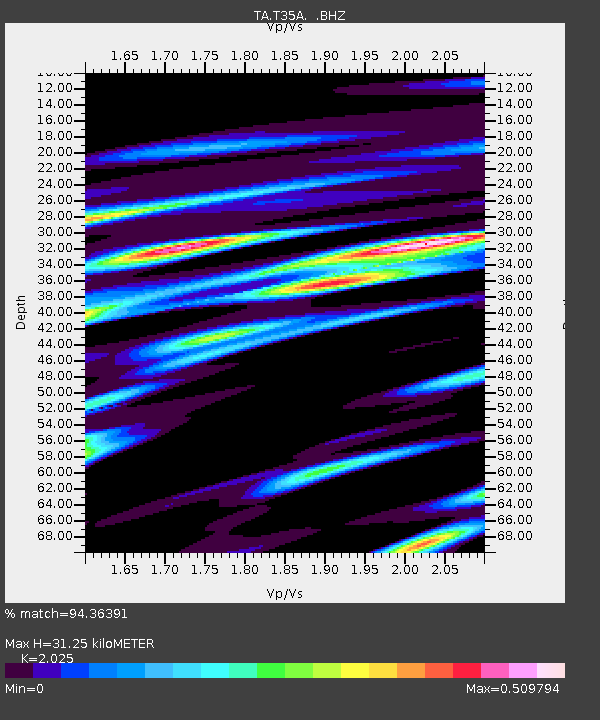
| Estimated Moho Depth: |
31.25 km |
| Estimated Crust Vp/Vs: |
2.03 |
| Assumed Crust Vp: |
6.483 km/s |
| Estimated Crust Vs: |
3.201 km/s |
| Estimated Crust Poisson's Ratio: |
0.34 |
|
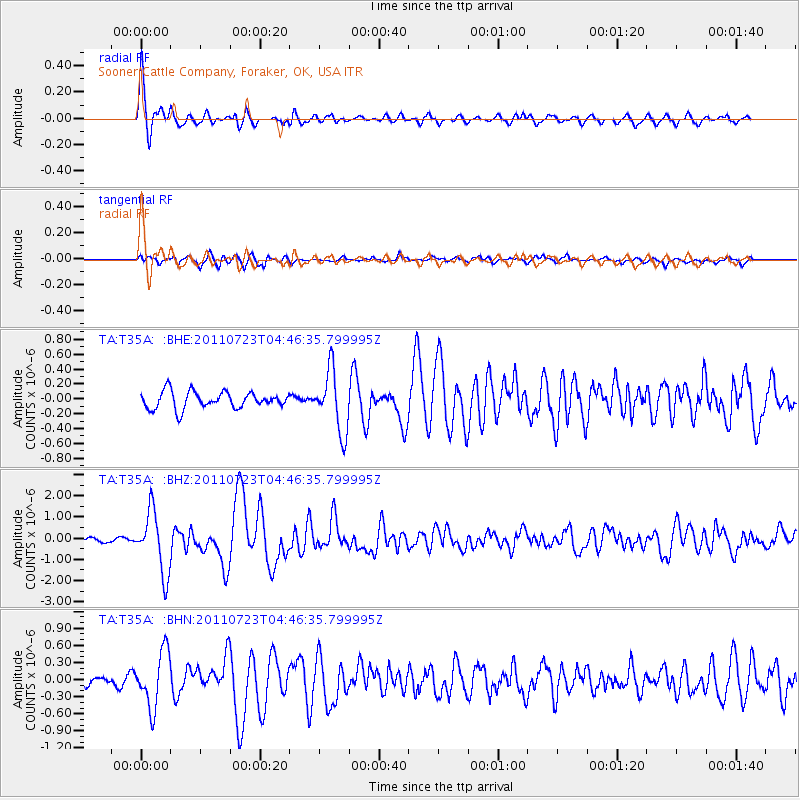
| Radial Match: |
94.36391 % |
| Radial Bump: |
394 |
| Transverse Match: |
67.56144 % |
| Transverse Bump: |
400 |
| SOD ConfigId: |
405110 |
| Insert Time: |
2011-12-29 05:00:05.030 +0000 |
| GWidth: |
2.5 |
| Max Bumps: |
400 |
| Tol: |
0.001 |
|
Signal To Noise
| Channel | StoN | STA | LTA |
| TA:T35A: :BHZ:20110723T04:46:35.799995Z | 9.568045 | 1.4427047E-6 | 1.5078365E-7 |
| TA:T35A: :BHN:20110723T04:46:35.799995Z | 3.626121 | 4.875204E-7 | 1.3444681E-7 |
| TA:T35A: :BHE:20110723T04:46:35.799995Z | 3.647509 | 4.1069788E-7 | 1.1259681E-7 |
| Arrivals |
| Ps | 5.0 SECOND |
| PpPs | 14 SECOND |
| PsPs/PpSs | 19 SECOND |


