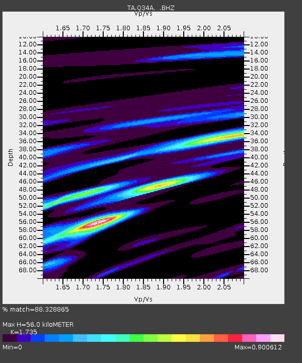
Q34A Chapman, KS, USA - Earthquake Result Viewer
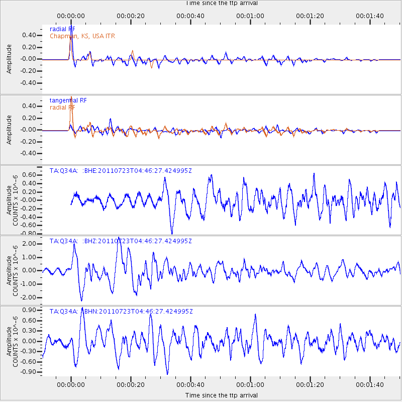
Earthquake location: Near East Coast Of Honshu, Japan
Earthquake latitude/longitude: 38.9/141.8
Earthquake time(UTC): 2011/07/23 (204) 04:34:24 GMT
Earthquake Depth: 41 km
Earthquake Magnitude: 5.9 MB, 5.9 MS, 6.4 MW, 6.3 MW
Earthquake Catalog/Contributor: WHDF/NEIC
Network: TA USArray Transportable Network (new EarthScope stations)
Station: Q34A Chapman, KS, USA
Lat/Lon: 38.92 N/96.94 W
Elevation: 378 m
Distance: 85.7 deg
Az: 41.978 deg
Baz: 318.005 deg
Ray Param: 0.044539064
Estimated Moho Depth: 56.0 km
Estimated Crust Vp/Vs: 1.74
Assumed Crust Vp: 6.483 km/s
Estimated Crust Vs: 3.736 km/s
Estimated Crust Poisson's Ratio: 0.25
Radial Match: 88.328865 %
Radial Bump: 400
Transverse Match: 73.006645 %
Transverse Bump: 400
SOD ConfigId: 405110
Insert Time: 2011-12-29 05:00:17.582 +0000
GWidth: 2.5
Max Bumps: 400
Tol: 0.001

Signal To Noise

ChannelStoNSTALTA
TA:Q34A: :BHZ:20110723T04:46:27.424995Z8.2261131.2280776E-61.4929014E-7
TA:Q34A: :BHN:20110723T04:46:27.424995Z3.07121165.254256E-71.7108088E-7
TA:Q34A: :BHE:20110723T04:46:27.424995Z3.70363643.7764292E-71.0196544E-7
Arrivals
Ps6.5 SECOND
PpPs23 SECOND
PsPs/PpSs30 SECOND