You are here: Home > Network List > TA - USArray Transportable Network (new EarthScope stations) Stations List
> Station R34A Isabella, Hillsboro, KS, USA > Earthquake Result Viewer
R34A Isabella, Hillsboro, KS, USA - Earthquake Result Viewer

| Earthquake location: |
Near East Coast Of Honshu, Japan |
| Earthquake latitude/longitude: |
38.9/141.8 |
| Earthquake time(UTC): |
2011/07/23 (204) 04:34:24 GMT |
| Earthquake Depth: |
41 km |
| Earthquake Magnitude: |
5.9 MB, 5.9 MS, 6.4 MW, 6.3 MW |
| Earthquake Catalog/Contributor: |
WHDF/NEIC |
|
| Network: |
TA USArray Transportable Network (new EarthScope stations) |
| Station: |
R34A Isabella, Hillsboro, KS, USA |
| Lat/Lon: |
38.30 N/97.25 W |
| Elevation: |
437 m |
|
| Distance: |
86.0 deg |
| Az: |
42.573 deg |
| Baz: |
317.859 deg |
| Ray Param: |
0.04432662 |
| Estimated Moho Depth: |
41.25 km |
| Estimated Crust Vp/Vs: |
1.87 |
| Assumed Crust Vp: |
6.483 km/s |
| Estimated Crust Vs: |
3.471 km/s |
| Estimated Crust Poisson's Ratio: |
0.30 |
|
| Radial Match: |
90.15576 % |
| Radial Bump: |
340 |
| Transverse Match: |
74.59369 % |
| Transverse Bump: |
400 |
| SOD ConfigId: |
405110 |
| Insert Time: |
2011-12-29 05:00:43.101 +0000 |
| GWidth: |
2.5 |
| Max Bumps: |
400 |
| Tol: |
0.001 |
|
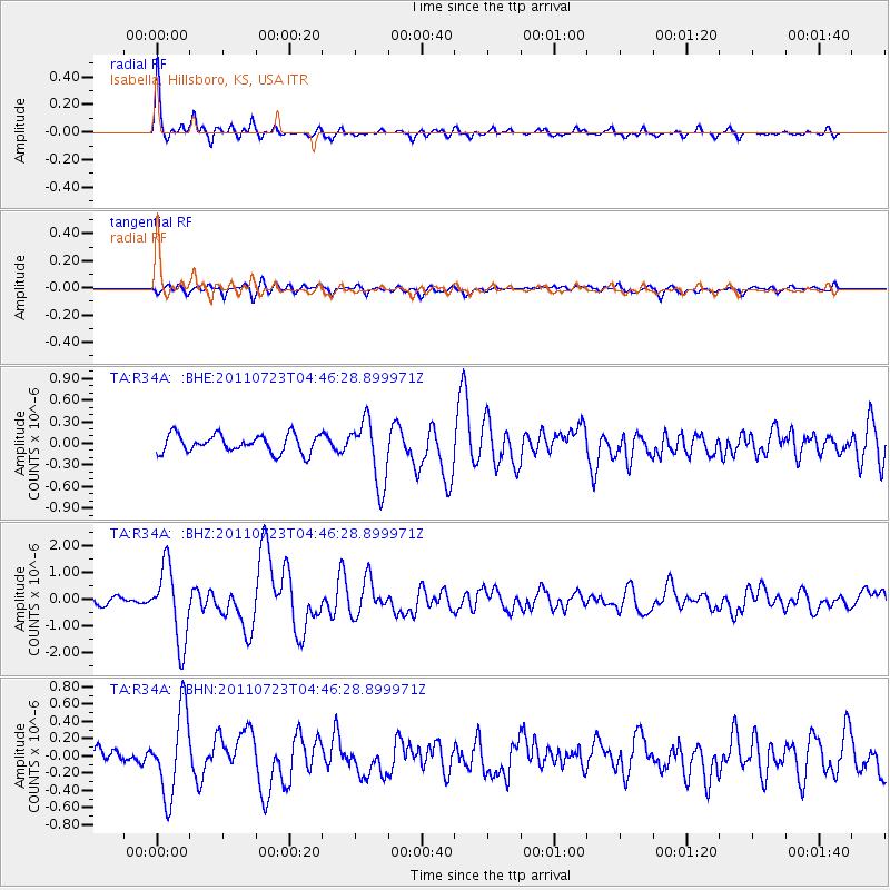
Signal To Noise
| Channel | StoN | STA | LTA |
| TA:R34A: :BHZ:20110723T04:46:28.899971Z | 8.999343 | 1.4055886E-6 | 1.5618791E-7 |
| TA:R34A: :BHN:20110723T04:46:28.899971Z | 6.0933228 | 4.8497964E-7 | 7.959198E-8 |
| TA:R34A: :BHE:20110723T04:46:28.899971Z | 3.6247113 | 4.5063643E-7 | 1.2432339E-7 |
| Arrivals |
| Ps | 5.6 SECOND |
| PpPs | 18 SECOND |
| PsPs/PpSs | 23 SECOND |


