V37A Hulbert, OK, USA - Earthquake Result Viewer
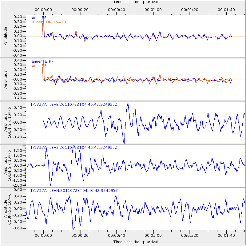
Earthquake location: Near East Coast Of Honshu, Japan
Earthquake latitude/longitude: 38.9/141.8
Earthquake time(UTC): 2011/07/23 (204) 04:34:24 GMT
Earthquake Depth: 41 km
Earthquake Magnitude: 5.9 MB, 5.9 MS, 6.4 MW, 6.3 MW
Earthquake Catalog/Contributor: WHDF/NEIC
Network: TA USArray Transportable Network (new EarthScope stations)
Station: V37A Hulbert, OK, USA
Lat/Lon: 35.88 N/95.14 W
Elevation: 219 m
Distance: 88.9 deg
Az: 42.911 deg
Baz: 319.139 deg
Ray Param: 0.042191584
Estimated Moho Depth: 43.5 km
Estimated Crust Vp/Vs: 1.73
Assumed Crust Vp: 6.498 km/s
Estimated Crust Vs: 3.756 km/s
Estimated Crust Poisson's Ratio: 0.25
Radial Match: 84.316376 %
Radial Bump: 400
Transverse Match: 68.04382 %
Transverse Bump: 400
SOD ConfigId: 405110
Insert Time: 2011-12-29 05:02:14.057 +0000
GWidth: 2.5
Max Bumps: 400
Tol: 0.001

Signal To Noise

ChannelStoNSTALTA
TA:V37A: :BHZ:20110723T04:46:42.924995Z5.55840831.0625497E-61.911608E-7
TA:V37A: :BHN:20110723T04:46:42.924995Z1.65489582.368394E-71.4311439E-7
TA:V37A: :BHE:20110723T04:46:42.924995Z2.1619922.0567987E-79.5134425E-8
Arrivals
Ps5.0 SECOND
PpPs18 SECOND
PsPs/PpSs23 SECOND