V38A Canehill, AR, USA - Earthquake Result Viewer
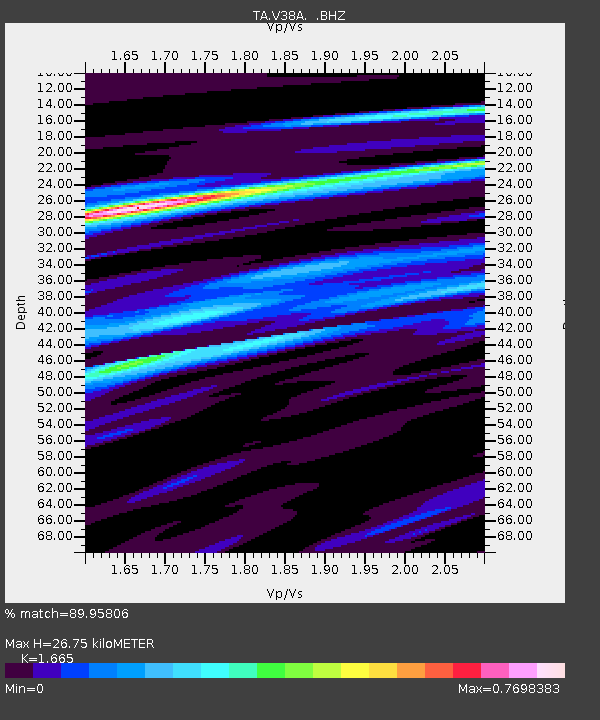
Earthquake location: Near East Coast Of Honshu, Japan
Earthquake latitude/longitude: 38.9/141.8
Earthquake time(UTC): 2011/07/23 (204) 04:34:24 GMT
Earthquake Depth: 41 km
Earthquake Magnitude: 5.9 MB, 5.9 MS, 6.4 MW, 6.3 MW
Earthquake Catalog/Contributor: WHDF/NEIC
Network: TA USArray Transportable Network (new EarthScope stations)
Station: V38A Canehill, AR, USA
Lat/Lon: 35.86 N/94.41 W
Elevation: 372 m
Distance: 89.3 deg
Az: 42.472 deg
Baz: 319.56 deg
Ray Param: 0.041897908
Estimated Moho Depth: 26.75 km
Estimated Crust Vp/Vs: 1.66
Assumed Crust Vp: 6.498 km/s
Estimated Crust Vs: 3.902 km/s
Estimated Crust Poisson's Ratio: 0.22
Radial Match: 89.95806 %
Radial Bump: 400
Transverse Match: 74.066696 %
Transverse Bump: 400
SOD ConfigId: 405110
Insert Time: 2011-12-29 05:02:26.865 +0000
GWidth: 2.5
Max Bumps: 400
Tol: 0.001

Signal To Noise

ChannelStoNSTALTA
TA:V38A: :BHZ:20110723T04:46:44.82502Z10.5967441.3146113E-61.2405803E-7
TA:V38A: :BHN:20110723T04:46:44.82502Z4.1376543.6649033E-78.857443E-8
TA:V38A: :BHE:20110723T04:46:44.82502Z2.90352232.8287184E-79.742369E-8
Arrivals
Ps2.8 SECOND
PpPs11 SECOND
PsPs/PpSs14 SECOND