You are here: Home > Network List > TA - USArray Transportable Network (new EarthScope stations) Stations List
> Station H32A Carlson Farm, Erwin, SD, USA > Earthquake Result Viewer
H32A Carlson Farm, Erwin, SD, USA - Earthquake Result Viewer
| Earthquake location: |
Near East Coast Of Honshu, Japan |
| Earthquake latitude/longitude: |
38.9/141.8 |
| Earthquake time(UTC): |
2011/07/23 (204) 04:34:24 GMT |
| Earthquake Depth: |
41 km |
| Earthquake Magnitude: |
5.9 MB, 5.9 MS, 6.4 MW, 6.3 MW |
| Earthquake Catalog/Contributor: |
WHDF/NEIC |
|
| Network: |
TA USArray Transportable Network (new EarthScope stations) |
| Station: |
H32A Carlson Farm, Erwin, SD, USA |
| Lat/Lon: |
44.50 N/97.44 W |
| Elevation: |
573 m |
|
| Distance: |
81.3 deg |
| Az: |
38.472 deg |
| Baz: |
317.278 deg |
| Ray Param: |
0.04762364 |
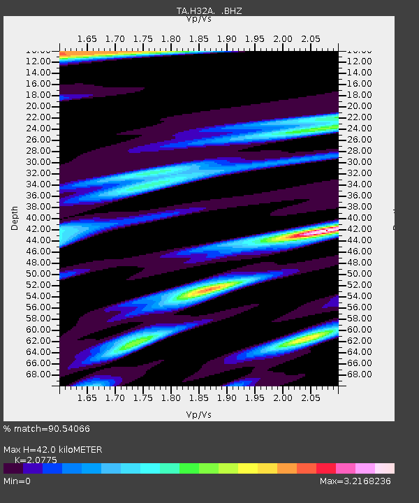
| Estimated Moho Depth: |
42.0 km |
| Estimated Crust Vp/Vs: |
2.08 |
| Assumed Crust Vp: |
6.552 km/s |
| Estimated Crust Vs: |
3.154 km/s |
| Estimated Crust Poisson's Ratio: |
0.35 |
|
| Radial Match: |
90.54066 % |
| Radial Bump: |
400 |
| Transverse Match: |
75.73463 % |
| Transverse Bump: |
393 |
| SOD ConfigId: |
405110 |
| Insert Time: |
2011-12-29 05:04:35.140 +0000 |
| GWidth: |
2.5 |
| Max Bumps: |
400 |
| Tol: |
0.001 |
|
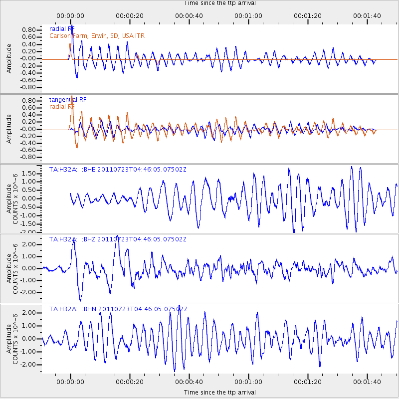
Signal To Noise
| Channel | StoN | STA | LTA |
| TA:H32A: :BHZ:20110723T04:46:05.07502Z | 21.515026 | 1.5265441E-6 | 7.095247E-8 |
| TA:H32A: :BHN:20110723T04:46:05.07502Z | 2.2765398 | 7.0441416E-7 | 3.0942317E-7 |
| TA:H32A: :BHE:20110723T04:46:05.07502Z | 3.1766653 | 7.5507205E-7 | 2.3769329E-7 |
| Arrivals |
| Ps | 7.1 SECOND |
| PpPs | 19 SECOND |
| PsPs/PpSs | 26 SECOND |


