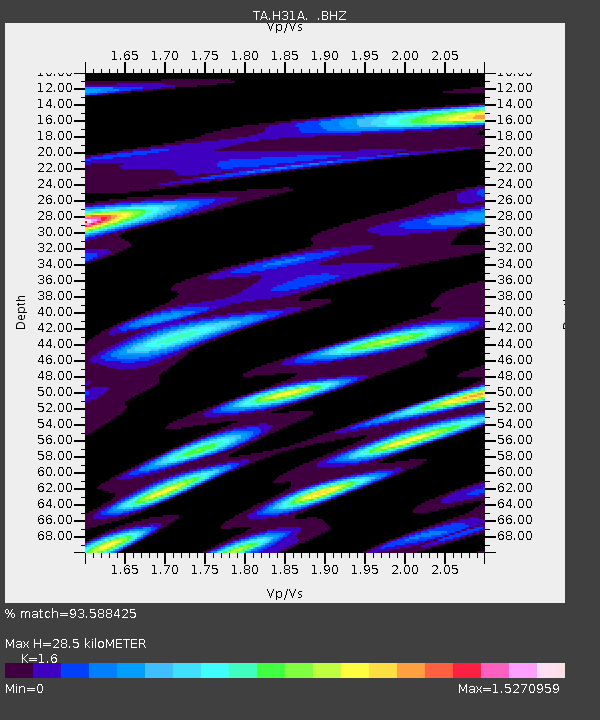
H31A Wolsey, SD, USA - Earthquake Result Viewer

Earthquake location: Near East Coast Of Honshu, Japan
Earthquake latitude/longitude: 38.9/141.8
Earthquake time(UTC): 2011/07/23 (204) 04:34:24 GMT
Earthquake Depth: 41 km
Earthquake Magnitude: 5.9 MB, 5.9 MS, 6.4 MW, 6.3 MW
Earthquake Catalog/Contributor: WHDF/NEIC
Network: TA USArray Transportable Network (new EarthScope stations)
Station: H31A Wolsey, SD, USA
Lat/Lon: 44.48 N/98.48 W
Elevation: 415 m
Distance: 80.8 deg
Az: 39.04 deg
Baz: 316.639 deg
Ray Param: 0.047966346
Estimated Moho Depth: 28.5 km
Estimated Crust Vp/Vs: 1.60
Assumed Crust Vp: 6.53 km/s
Estimated Crust Vs: 4.082 km/s
Estimated Crust Poisson's Ratio: 0.18
Radial Match: 93.588425 %
Radial Bump: 400
Transverse Match: 84.543076 %
Transverse Bump: 400
SOD ConfigId: 405110
Insert Time: 2011-12-29 05:06:29.925 +0000
GWidth: 2.5
Max Bumps: 400
Tol: 0.001

Signal To Noise

ChannelStoNSTALTA
TA:H31A: :BHZ:20110723T04:46:02.474983Z14.986361.6948194E-61.130908E-7
TA:H31A: :BHN:20110723T04:46:02.474983Z3.45331265.623387E-71.6284037E-7
TA:H31A: :BHE:20110723T04:46:02.474983Z3.73148375.658428E-71.5164017E-7
Arrivals
Ps2.7 SECOND
PpPs11 SECOND
PsPs/PpSs14 SECOND