You are here: Home > Network List > 7A - Mid-Atlantic Geophysical Integrative Collaboration Stations List
> Station CABN Riverton, West Virginia USA > Earthquake Result Viewer
CABN Riverton, West Virginia USA - Earthquake Result Viewer
| Earthquake location: |
Near Coast Of Northern Chile |
| Earthquake latitude/longitude: |
-19.6/-70.8 |
| Earthquake time(UTC): |
2014/04/01 (091) 23:46:46 GMT |
| Earthquake Depth: |
20 km |
| Earthquake Magnitude: |
8.2 MWW, 8.0 MI, 8.1 MWC |
| Earthquake Catalog/Contributor: |
NEIC PDE/NEIC COMCAT |
|
| Network: |
7A Mid-Atlantic Geophysical Integrative Collaboration |
| Station: |
CABN Riverton, West Virginia USA |
| Lat/Lon: |
38.72 N/79.44 W |
| Elevation: |
910 m |
|
| Distance: |
58.6 deg |
| Az: |
352.102 deg |
| Baz: |
170.47 deg |
| Ray Param: |
0.062706776 |
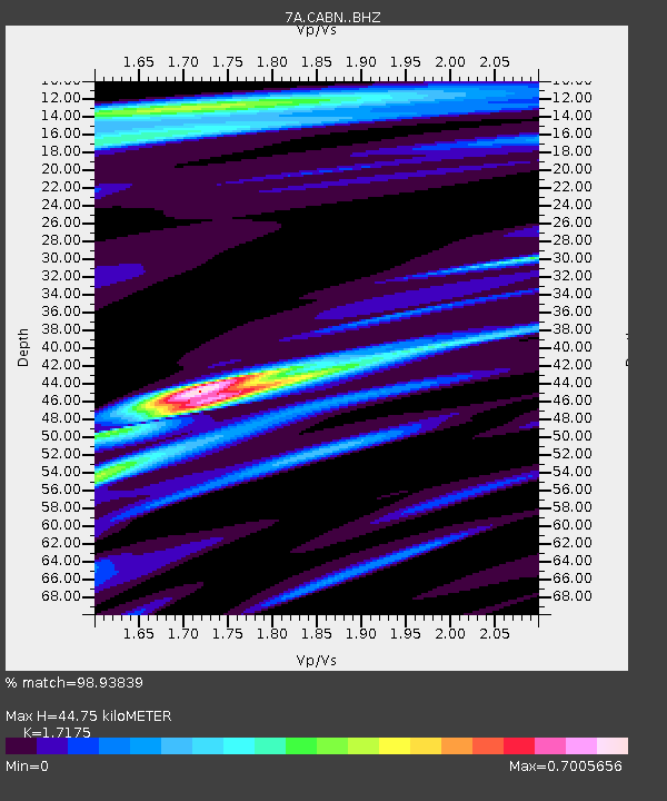
| Estimated Moho Depth: |
44.75 km |
| Estimated Crust Vp/Vs: |
1.72 |
| Assumed Crust Vp: |
6.159 km/s |
| Estimated Crust Vs: |
3.586 km/s |
| Estimated Crust Poisson's Ratio: |
0.24 |
|
| Radial Match: |
98.93839 % |
| Radial Bump: |
269 |
| Transverse Match: |
93.72785 % |
| Transverse Bump: |
400 |
| SOD ConfigId: |
3390531 |
| Insert Time: |
2019-04-10 23:33:13.172 +0000 |
| GWidth: |
2.5 |
| Max Bumps: |
400 |
| Tol: |
0.001 |
|

Signal To Noise
| Channel | StoN | STA | LTA |
| 7A:CABN: :BHZ:20140401T23:56:12.150005Z | 9.935976 | 2.1081783E-6 | 2.1217627E-7 |
| 7A:CABN: :BHN:20140401T23:56:12.150005Z | 3.8582091 | 1.1451274E-6 | 2.9680282E-7 |
| 7A:CABN: :BHE:20140401T23:56:12.150005Z | 2.626507 | 3.3282893E-7 | 1.2671923E-7 |
| Arrivals |
| Ps | 5.5 SECOND |
| PpPs | 19 SECOND |
| PsPs/PpSs | 24 SECOND |


