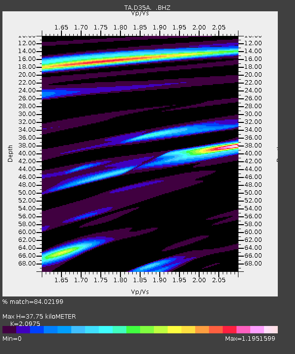
D35A Remer, MN, USA - Earthquake Result Viewer

Earthquake location: Near East Coast Of Honshu, Japan
Earthquake latitude/longitude: 38.9/141.8
Earthquake time(UTC): 2011/07/23 (204) 04:34:24 GMT
Earthquake Depth: 41 km
Earthquake Magnitude: 5.9 MB, 5.9 MS, 6.4 MW, 6.3 MW
Earthquake Catalog/Contributor: WHDF/NEIC
Network: TA USArray Transportable Network (new EarthScope stations)
Station: D35A Remer, MN, USA
Lat/Lon: 47.08 N/94.05 W
Elevation: 427 m
Distance: 80.9 deg
Az: 34.948 deg
Baz: 319.152 deg
Ray Param: 0.047864888
Estimated Moho Depth: 37.75 km
Estimated Crust Vp/Vs: 2.10
Assumed Crust Vp: 6.419 km/s
Estimated Crust Vs: 3.06 km/s
Estimated Crust Poisson's Ratio: 0.35
Radial Match: 84.02199 %
Radial Bump: 400
Transverse Match: 78.24982 %
Transverse Bump: 400
SOD ConfigId: 405110
Insert Time: 2011-12-29 05:07:28.351 +0000
GWidth: 2.5
Max Bumps: 400
Tol: 0.001

Signal To Noise

ChannelStoNSTALTA
TA:D35A: :BHZ:20110723T04:46:03.250007Z6.97472761.1248061E-61.6126882E-7
TA:D35A: :BHN:20110723T04:46:03.250007Z3.73425674.469034E-71.1967667E-7
TA:D35A: :BHE:20110723T04:46:03.250007Z2.28034692.8126308E-71.2334225E-7
Arrivals
Ps6.6 SECOND
PpPs18 SECOND
PsPs/PpSs24 SECOND