You are here: Home > Network List > TA - USArray Transportable Network (new EarthScope stations) Stations List
> Station C35A Jirik Farms, Max, MN, USA > Earthquake Result Viewer
C35A Jirik Farms, Max, MN, USA - Earthquake Result Viewer
| Earthquake location: |
Near East Coast Of Honshu, Japan |
| Earthquake latitude/longitude: |
38.9/141.8 |
| Earthquake time(UTC): |
2011/07/23 (204) 04:34:24 GMT |
| Earthquake Depth: |
41 km |
| Earthquake Magnitude: |
5.9 MB, 5.9 MS, 6.4 MW, 6.3 MW |
| Earthquake Catalog/Contributor: |
WHDF/NEIC |
|
| Network: |
TA USArray Transportable Network (new EarthScope stations) |
| Station: |
C35A Jirik Farms, Max, MN, USA |
| Lat/Lon: |
47.70 N/93.98 W |
| Elevation: |
426 m |
|
| Distance: |
80.5 deg |
| Az: |
34.497 deg |
| Baz: |
319.136 deg |
| Ray Param: |
0.04816081 |
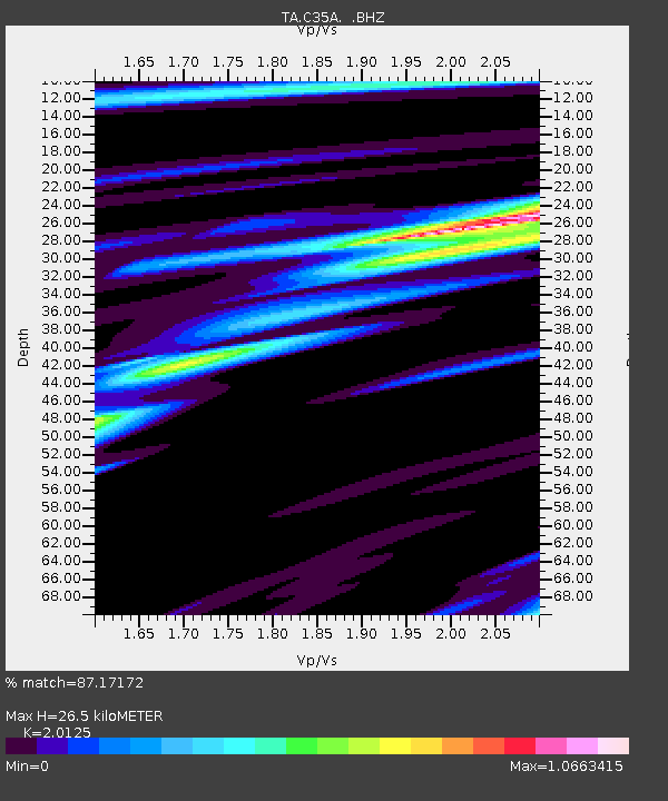
| Estimated Moho Depth: |
26.5 km |
| Estimated Crust Vp/Vs: |
2.01 |
| Assumed Crust Vp: |
6.571 km/s |
| Estimated Crust Vs: |
3.265 km/s |
| Estimated Crust Poisson's Ratio: |
0.34 |
|
| Radial Match: |
87.17172 % |
| Radial Bump: |
400 |
| Transverse Match: |
80.74075 % |
| Transverse Bump: |
359 |
| SOD ConfigId: |
405110 |
| Insert Time: |
2011-12-29 05:08:44.029 +0000 |
| GWidth: |
2.5 |
| Max Bumps: |
400 |
| Tol: |
0.001 |
|

Signal To Noise
| Channel | StoN | STA | LTA |
| TA:C35A: :BHZ:20110723T04:46:00.95002Z | 14.0570545 | 1.4230741E-6 | 1.0123558E-7 |
| TA:C35A: :BHN:20110723T04:46:00.95002Z | 3.5082228 | 5.495527E-7 | 1.5664703E-7 |
| TA:C35A: :BHE:20110723T04:46:00.95002Z | 5.3497195 | 4.479562E-7 | 8.373453E-8 |
| Arrivals |
| Ps | 4.2 SECOND |
| PpPs | 12 SECOND |
| PsPs/PpSs | 16 SECOND |


