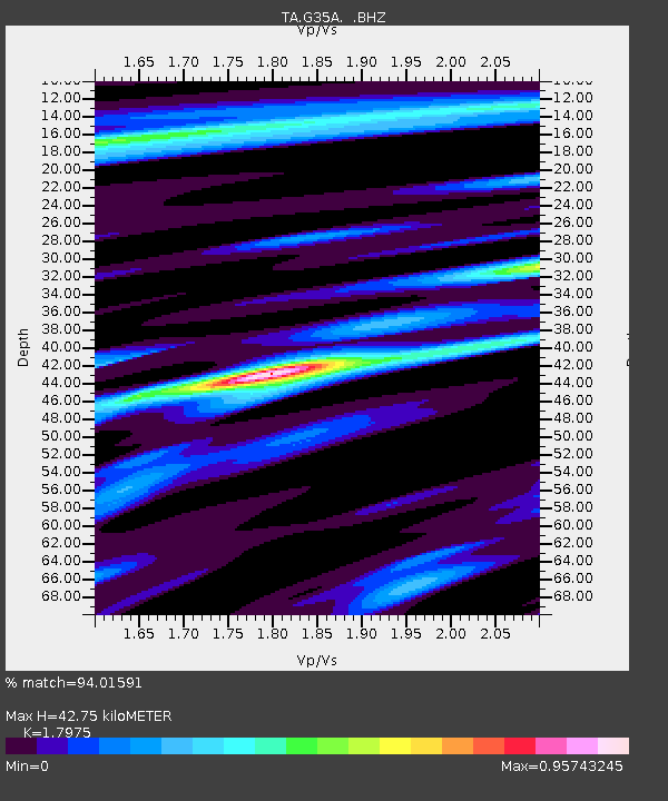
G35A Watkins, MN, USA - Earthquake Result Viewer
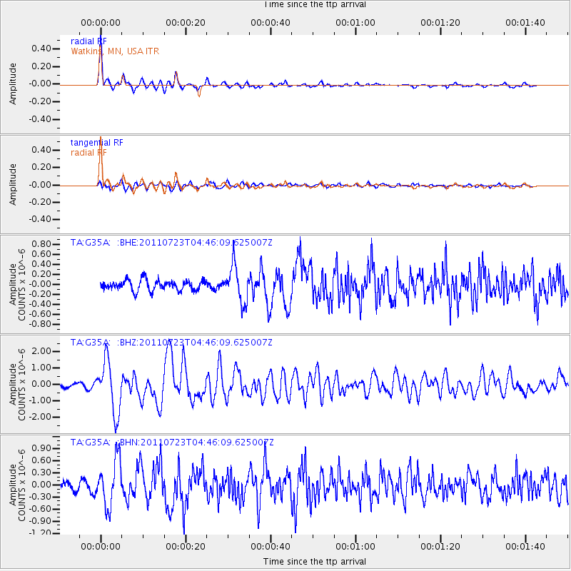
Earthquake location: Near East Coast Of Honshu, Japan
Earthquake latitude/longitude: 38.9/141.8
Earthquake time(UTC): 2011/07/23 (204) 04:34:24 GMT
Earthquake Depth: 41 km
Earthquake Magnitude: 5.9 MB, 5.9 MS, 6.4 MW, 6.3 MW
Earthquake Catalog/Contributor: WHDF/NEIC
Network: TA USArray Transportable Network (new EarthScope stations)
Station: G35A Watkins, MN, USA
Lat/Lon: 45.22 N/94.49 W
Elevation: 361 m
Distance: 82.2 deg
Az: 36.409 deg
Baz: 319.056 deg
Ray Param: 0.047017217
Estimated Moho Depth: 42.75 km
Estimated Crust Vp/Vs: 1.80
Assumed Crust Vp: 6.571 km/s
Estimated Crust Vs: 3.655 km/s
Estimated Crust Poisson's Ratio: 0.28
Radial Match: 94.01591 %
Radial Bump: 318
Transverse Match: 75.66045 %
Transverse Bump: 400
SOD ConfigId: 405110
Insert Time: 2011-12-29 05:08:47.719 +0000
GWidth: 2.5
Max Bumps: 400
Tol: 0.001

Signal To Noise

ChannelStoNSTALTA
TA:G35A: :BHZ:20110723T04:46:09.625007Z15.525211.587098E-61.02227155E-7
TA:G35A: :BHN:20110723T04:46:09.625007Z7.02244045.8860024E-78.381705E-8
TA:G35A: :BHE:20110723T04:46:09.625007Z3.610053.6748284E-71.0179439E-7
Arrivals
Ps5.3 SECOND
PpPs18 SECOND
PsPs/PpSs23 SECOND