You are here: Home > Network List > TA - USArray Transportable Network (new EarthScope stations) Stations List
> Station M37A Trindle Farm, Earlham, IA, USA > Earthquake Result Viewer
M37A Trindle Farm, Earlham, IA, USA - Earthquake Result Viewer
| Earthquake location: |
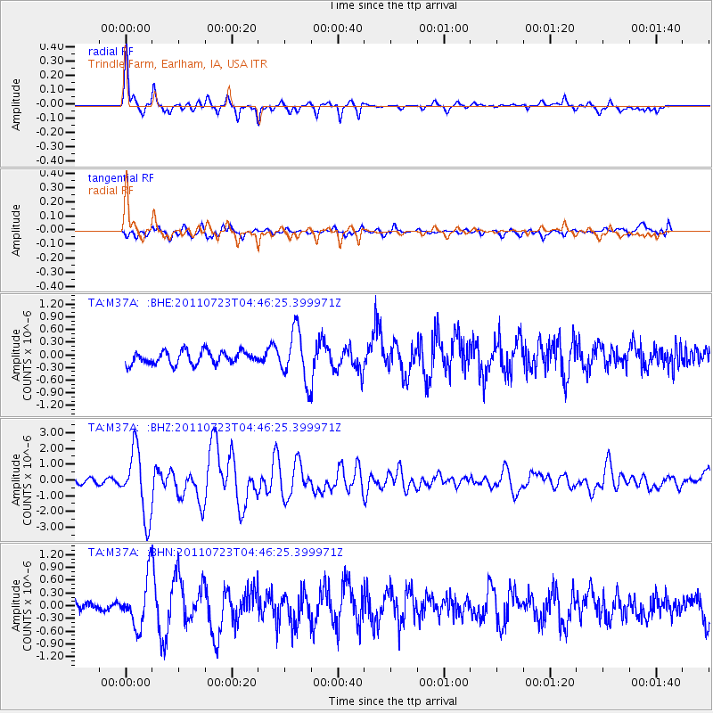
Near East Coast Of Honshu, Japan |
| Earthquake latitude/longitude: |
38.9/141.8 |
| Earthquake time(UTC): |
2011/07/23 (204) 04:34:24 GMT |
| Earthquake Depth: |
41 km |
| Earthquake Magnitude: |
5.9 MB, 5.9 MS, 6.4 MW, 6.3 MW |
| Earthquake Catalog/Contributor: |
WHDF/NEIC |
|
| Network: |
TA USArray Transportable Network (new EarthScope stations) |
| Station: |
M37A Trindle Farm, Earlham, IA, USA |
| Lat/Lon: |
41.40 N/94.06 W |
| Elevation: |
325 m |
|
| Distance: |
85.3 deg |
| Az: |
38.673 deg |
| Baz: |
319.597 deg |
| Ray Param: |
0.044832043 |
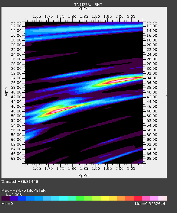
| Estimated Moho Depth: |
34.75 km |
| Estimated Crust Vp/Vs: |
2.01 |
| Assumed Crust Vp: |
6.498 km/s |
| Estimated Crust Vs: |
3.241 km/s |
| Estimated Crust Poisson's Ratio: |
0.33 |
|
| Radial Match: |
86.31446 % |
| Radial Bump: |
371 |
| Transverse Match: |
73.08064 % |
| Transverse Bump: |
400 |
| SOD ConfigId: |
405110 |
| Insert Time: |
2011-12-29 05:10:59.311 +0000 |
| GWidth: |
2.5 |
| Max Bumps: |
400 |
| Tol: |
0.001 |
|
Signal To Noise
| Channel | StoN | STA | LTA |
| TA:M37A: :BHZ:20110723T04:46:25.399971Z | 12.040113 | 2.1139276E-6 | 1.7557373E-7 |
| TA:M37A: :BHN:20110723T04:46:25.399971Z | 5.9232225 | 5.800943E-7 | 9.79356E-8 |
| TA:M37A: :BHE:20110723T04:46:25.399971Z | 3.885132 | 5.989257E-7 | 1.5415839E-7 |
| Arrivals |
| Ps | 5.5 SECOND |
| PpPs | 16 SECOND |
| PsPs/PpSs | 21 SECOND |


