You are here: Home > Network List > TA - USArray Transportable Network (new EarthScope stations) Stations List
> Station N59A State Game Land 141, Hazleton, PA, USA > Earthquake Result Viewer
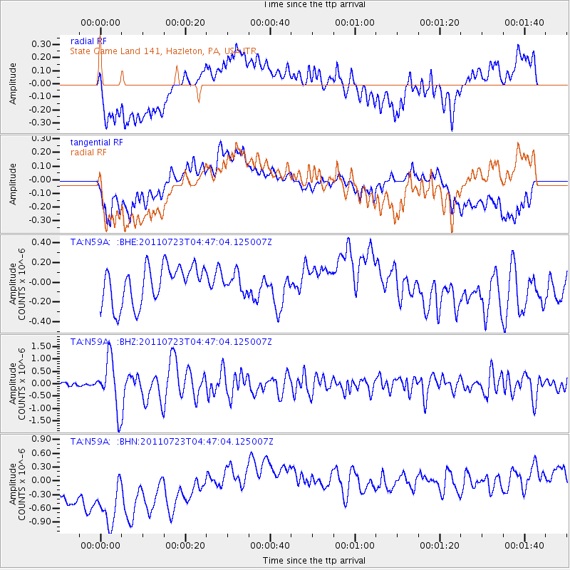
N59A State Game Land 141, Hazleton, PA, USA - Earthquake Result Viewer
*The percent match for this event was below the threshold and hence no stack was calculated.
| Earthquake location: |
Near East Coast Of Honshu, Japan |
| Earthquake latitude/longitude: |
38.9/141.8 |
| Earthquake time(UTC): |
2011/07/23 (204) 04:34:24 GMT |
| Earthquake Depth: |
41 km |
| Earthquake Magnitude: |
5.9 MB, 5.9 MS, 6.4 MW, 6.3 MW |
| Earthquake Catalog/Contributor: |
WHDF/NEIC |
|
| Network: |
TA USArray Transportable Network (new EarthScope stations) |
| Station: |
N59A State Game Land 141, Hazleton, PA, USA |
| Lat/Lon: |
40.92 N/75.77 W |
| Elevation: |
508 m |
|
| Distance: |
93.5 deg |
| Az: |
27.586 deg |
| Baz: |
331.522 deg |
| Ray Param: |
$rayparam |
*The percent match for this event was below the threshold and hence was not used in the summary stack. |
|
| Radial Match: |
11.997854 % |
| Radial Bump: |
400 |
| Transverse Match: |
20.925005 % |
| Transverse Bump: |
400 |
| SOD ConfigId: |
405110 |
| Insert Time: |
2011-12-29 05:11:38.088 +0000 |
| GWidth: |
2.5 |
| Max Bumps: |
400 |
| Tol: |
0.001 |
|
Signal To Noise
| Channel | StoN | STA | LTA |
| TA:N59A: :BHZ:20110723T04:47:04.125007Z | 5.244033 | 1.0465424E-6 | 1.9956825E-7 |
| TA:N59A: :BHN:20110723T04:47:04.125007Z | 1.1321322 | 2.0279344E-6 | 1.7912524E-6 |
| TA:N59A: :BHE:20110723T04:47:04.125007Z | 0.48841515 | 9.404749E-8 | 1.9255646E-7 |
| Arrivals |
| Ps | |
| PpPs | |
| PsPs/PpSs | |


