You are here: Home > Network List > TA - USArray Transportable Network (new EarthScope stations) Stations List
> Station L37A Phoenix Point, Boone, IA, USA > Earthquake Result Viewer
L37A Phoenix Point, Boone, IA, USA - Earthquake Result Viewer
| Earthquake location: |
Near East Coast Of Honshu, Japan |
| Earthquake latitude/longitude: |
38.9/141.8 |
| Earthquake time(UTC): |
2011/07/23 (204) 04:34:24 GMT |
| Earthquake Depth: |
41 km |
| Earthquake Magnitude: |
5.9 MB, 5.9 MS, 6.4 MW, 6.3 MW |
| Earthquake Catalog/Contributor: |
WHDF/NEIC |
|
| Network: |
TA USArray Transportable Network (new EarthScope stations) |
| Station: |
L37A Phoenix Point, Boone, IA, USA |
| Lat/Lon: |
42.12 N/93.75 W |
| Elevation: |
312 m |
|
| Distance: |
84.9 deg |
| Az: |
38.031 deg |
| Baz: |
319.742 deg |
| Ray Param: |
0.045121457 |
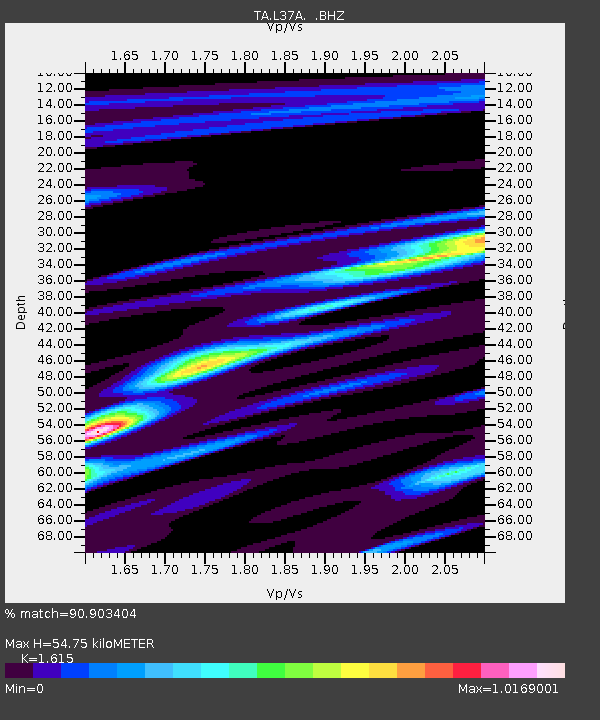
| Estimated Moho Depth: |
54.75 km |
| Estimated Crust Vp/Vs: |
1.62 |
| Assumed Crust Vp: |
6.53 km/s |
| Estimated Crust Vs: |
4.044 km/s |
| Estimated Crust Poisson's Ratio: |
0.19 |
|
| Radial Match: |
90.903404 % |
| Radial Bump: |
400 |
| Transverse Match: |
52.42124 % |
| Transverse Bump: |
400 |
| SOD ConfigId: |
405110 |
| Insert Time: |
2011-12-29 05:11:44.508 +0000 |
| GWidth: |
2.5 |
| Max Bumps: |
400 |
| Tol: |
0.001 |
|
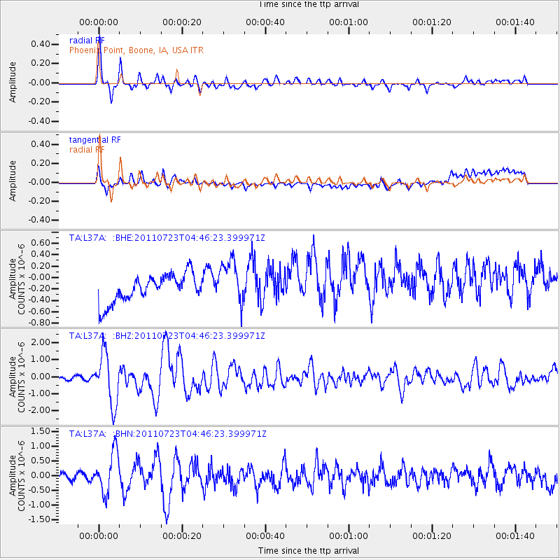
Signal To Noise
| Channel | StoN | STA | LTA |
| TA:L37A: :BHZ:20110723T04:46:23.399971Z | 15.848363 | 1.5378594E-6 | 9.703585E-8 |
| TA:L37A: :BHN:20110723T04:46:23.399971Z | 3.8928642 | 7.5563315E-7 | 1.9410724E-7 |
| TA:L37A: :BHE:20110723T04:46:23.399971Z | 1.6664307 | 3.9953306E-7 | 2.3975377E-7 |
| Arrivals |
| Ps | 5.3 SECOND |
| PpPs | 21 SECOND |
| PsPs/PpSs | 27 SECOND |


