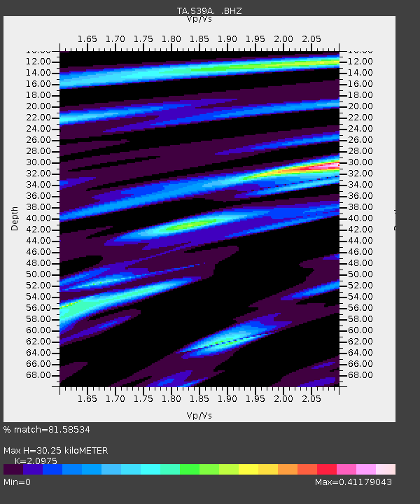
S39A Bolivar, MO, USA - Earthquake Result Viewer

Earthquake location: Near East Coast Of Honshu, Japan
Earthquake latitude/longitude: 38.9/141.8
Earthquake time(UTC): 2011/07/23 (204) 04:34:24 GMT
Earthquake Depth: 41 km
Earthquake Magnitude: 5.9 MB, 5.9 MS, 6.4 MW, 6.3 MW
Earthquake Catalog/Contributor: WHDF/NEIC
Network: TA USArray Transportable Network (new EarthScope stations)
Station: S39A Bolivar, MO, USA
Lat/Lon: 37.69 N/93.32 W
Elevation: 331 m
Distance: 88.5 deg
Az: 40.629 deg
Baz: 320.17 deg
Ray Param: 0.042510726
Estimated Moho Depth: 30.25 km
Estimated Crust Vp/Vs: 2.10
Assumed Crust Vp: 6.53 km/s
Estimated Crust Vs: 3.113 km/s
Estimated Crust Poisson's Ratio: 0.35
Radial Match: 81.58534 %
Radial Bump: 395
Transverse Match: 68.67902 %
Transverse Bump: 400
SOD ConfigId: 405110
Insert Time: 2011-12-29 05:13:05.194 +0000
GWidth: 2.5
Max Bumps: 400
Tol: 0.001

Signal To Noise

ChannelStoNSTALTA
TA:S39A: :BHZ:20110723T04:46:40.924995Z9.9240181.0511317E-61.0591795E-7
TA:S39A: :BHN:20110723T04:46:40.924995Z3.4605912.580149E-77.4558045E-8
TA:S39A: :BHE:20110723T04:46:40.924995Z1.97351672.7305228E-71.3835823E-7
Arrivals
Ps5.2 SECOND
PpPs14 SECOND
PsPs/PpSs19 SECOND