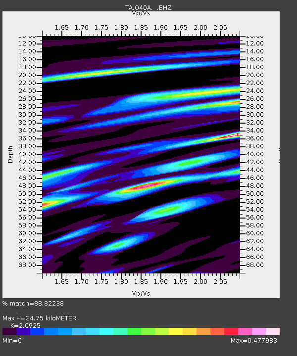
O40A La Belle, MO, USA - Earthquake Result Viewer

Earthquake location: Near East Coast Of Honshu, Japan
Earthquake latitude/longitude: 38.9/141.8
Earthquake time(UTC): 2011/07/23 (204) 04:34:24 GMT
Earthquake Depth: 41 km
Earthquake Magnitude: 5.9 MB, 5.9 MS, 6.4 MW, 6.3 MW
Earthquake Catalog/Contributor: WHDF/NEIC
Network: TA USArray Transportable Network (new EarthScope stations)
Station: O40A La Belle, MO, USA
Lat/Lon: 40.12 N/91.87 W
Elevation: 206 m
Distance: 87.3 deg
Az: 38.213 deg
Baz: 320.987 deg
Ray Param: 0.043362644
Estimated Moho Depth: 34.75 km
Estimated Crust Vp/Vs: 2.09
Assumed Crust Vp: 6.498 km/s
Estimated Crust Vs: 3.105 km/s
Estimated Crust Poisson's Ratio: 0.35
Radial Match: 88.82238 %
Radial Bump: 371
Transverse Match: 76.4025 %
Transverse Bump: 400
SOD ConfigId: 405110
Insert Time: 2011-12-29 05:13:17.489 +0000
GWidth: 2.5
Max Bumps: 400
Tol: 0.001

Signal To Noise

ChannelStoNSTALTA
TA:O40A: :BHZ:20110723T04:46:35.399971Z15.0252311.583946E-61.05419076E-7
TA:O40A: :BHN:20110723T04:46:35.399971Z5.2924395.990409E-71.13188065E-7
TA:O40A: :BHE:20110723T04:46:35.399971Z2.56992363.7362946E-71.4538543E-7
Arrivals
Ps6.0 SECOND
PpPs16 SECOND
PsPs/PpSs22 SECOND