You are here: Home > Network List > G - GEOSCOPE Stations List
> Station CAN Canberra, Australia > Earthquake Result Viewer
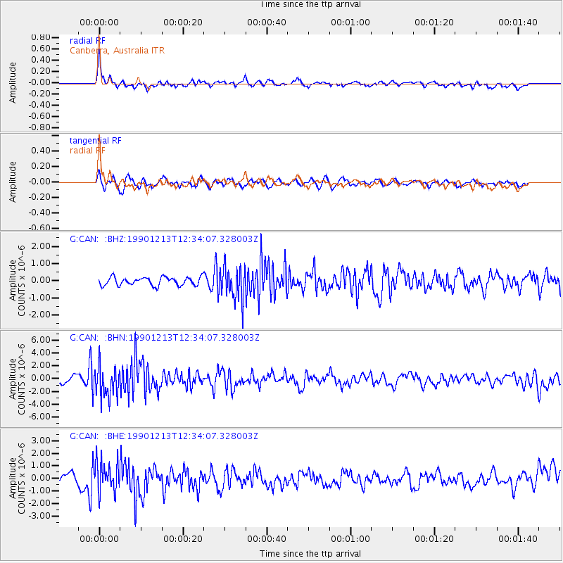
CAN Canberra, Australia - Earthquake Result Viewer
*The percent match for this event was below the threshold and hence no stack was calculated.
| Earthquake location: |
Minahassa Peninsula, Sulawesi |
| Earthquake latitude/longitude: |
1.1/124.0 |
| Earthquake time(UTC): |
1990/12/13 (347) 12:26:40 GMT |
| Earthquake Depth: |
33 km |
| Earthquake Magnitude: |
6.0 MB, 5.7 MS, 5.5 UNKNOWN |
| Earthquake Catalog/Contributor: |
WHDF/NEIC |
|
| Network: |
G GEOSCOPE |
| Station: |
CAN Canberra, Australia |
| Lat/Lon: |
35.32 S/149.00 E |
| Elevation: |
650 m |
|
| Distance: |
43.1 deg |
| Az: |
149.611 deg |
| Baz: |
321.793 deg |
| Ray Param: |
$rayparam |
*The percent match for this event was below the threshold and hence was not used in the summary stack. |
|
| Radial Match: |
76.96583 % |
| Radial Bump: |
400 |
| Transverse Match: |
58.84698 % |
| Transverse Bump: |
400 |
| SOD ConfigId: |
4480 |
| Insert Time: |
2010-02-26 21:48:30.944 +0000 |
| GWidth: |
2.5 |
| Max Bumps: |
400 |
| Tol: |
0.001 |
|
Signal To Noise
| Channel | StoN | STA | LTA |
| G:CAN: :BHN:19901213T12:34:07.328003Z | 4.031968 | 2.4404937E-6 | 6.05286E-7 |
| G:CAN: :BHE:19901213T12:34:07.328003Z | 2.6114643 | 1.1941804E-6 | 4.5728385E-7 |
| G:CAN: :BHZ:19901213T12:34:07.328003Z | 4.1079865 | 9.833304E-7 | 2.3937042E-7 |
| Arrivals |
| Ps | |
| PpPs | |
| PsPs/PpSs | |


